IMAGES TAKEN NEAR TO
Anchor Lane, WARE, SG12 0TF
Introduction
This page details the photographs taken nearby to Anchor Lane, SG12 0TF by members of the Geograph project.
The Geograph project started in 2005 with the aim of publishing, organising and preserving representative images for every square kilometre of Great Britain, Ireland and the Isle of Man.

There are currently over 7.5m images from over14,400 individuals and you can help contribute to the project by visiting https://www.geograph.org.uk
Image Map (Loading...)


Getting Data...Please wait
Leaflet Map data © OpenStreetMap
Images are licensed for reuse under creativecommons.org/licenses/by-sa/2.0
Notes
- Clicking on the map will re-center to the selected point.
- The higher the marker number, the further away the image location is from the centre of the postcode.
Image Listing (31 Images Found)
Images are licensed for reuse under creativecommons.org/licenses/by-sa/2.0
Image
Details
Distance
2
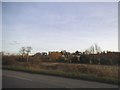
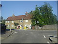
Wadesmill
Until 8 October 2004 when the Wadesmill Bypass was opened, traffic on the arterial A10 used to pass through the village of Wadesmill along this road. The houses on the roadside will have benefited from the reduction in the traffic and its noise, but businesses such as the Anchor public house on the left may have seen a drop in their passing trade.
Image: © Nigel Cox
Taken: 25 Nov 2007
0.07 miles
3
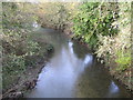
River Rib at Wadesmill
Viewed looking downstream from the old A10 Ermine Street bridge.
Image: © Nigel Cox
Taken: 25 Nov 2007
0.09 miles
6

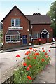
"The Anchor" public house, Wadesmill
This is a Grade II listed building, described at this https://historicengland.org.uk/listing/the-list/list-entry/1078711.
Image: © Jim Osley
Taken: 30 Jul 2016
0.11 miles
7
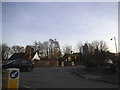
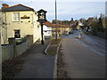
Anchor Lane at the junction of Ermine Street
Image: © David Howard
Taken: 16 Feb 2016
0.12 miles
8
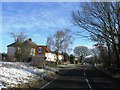
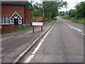
Cambridge Road at the junction of Anchor Lane
Image: © David Howard
Taken: 26 Jul 2012
0.12 miles
10
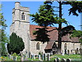
St. Mary's Church - Thundridge, Herts
This lovely church in Thundridge was built to replace the original church, which was demolished in 1853.
Image: © Catherine Edwards
Taken: 12 May 2005
0.13 miles