IMAGES TAKEN NEAR TO
Thundridge Business Park, WARE, SG12 0SS
Introduction
This page details the photographs taken nearby to Thundridge Business Park, SG12 0SS by members of the Geograph project.
The Geograph project started in 2005 with the aim of publishing, organising and preserving representative images for every square kilometre of Great Britain, Ireland and the Isle of Man.

There are currently over 7.5m images from over14,400 individuals and you can help contribute to the project by visiting https://www.geograph.org.uk
Image Map (Loading...)


Getting Data...Please wait
Leaflet Map data © OpenStreetMap
Images are licensed for reuse under creativecommons.org/licenses/by-sa/2.0
Notes
- Clicking on the map will re-center to the selected point.
- The higher the marker number, the further away the image location is from the centre of the postcode.
Image Listing (31 Images Found)
Images are licensed for reuse under creativecommons.org/licenses/by-sa/2.0
Image
Details
Distance
1

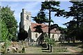
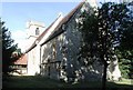
St Mary's Church, Thundridge
Grade II listed church built in 1853 to the designs of architect Benjamin Ferrey. Architectural description at this https://www.historicengland.org.uk/listing/the-list/list-entry/1281372.
Image: © Jim Osley
Taken: 30 Jul 2016
0.01 miles

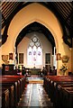
4
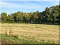
Trees along the river Rib and Thundridge church tower
Image: © Philip Jeffrey
Taken: 9 Oct 2022
0.07 miles
8
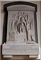
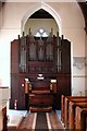
St Mary, Thundridge, Herts - Wall monument
Image: © John Salmon
Taken: 13 Sep 2003
0.09 miles