IMAGES TAKEN NEAR TO
Whempstead, WARE, SG12 0PL
Introduction
This page details the photographs taken nearby to SG12 0PL by members of the Geograph project.
The Geograph project started in 2005 with the aim of publishing, organising and preserving representative images for every square kilometre of Great Britain, Ireland and the Isle of Man.

There are currently over 7.5m images from over14,400 individuals and you can help contribute to the project by visiting https://www.geograph.org.uk
Image Map
Images are licensed for reuse under creativecommons.org/licenses/by-sa/2.0
Notes
- Clicking on the map will re-center to the selected point.
- The higher the marker number, the further away the image location is from the centre of the postcode.
Image Listing (5 Images Found)
Images are licensed for reuse under creativecommons.org/licenses/by-sa/2.0
Image
Details
Distance
1
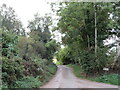
Mill Lane, Whempstead
Mill Lane is a minor lane leading out of the hamlet of Whempstead in north Hertfordshire.
Image: © Malc McDonald
Taken: 25 Sep 2022
0.03 miles
2
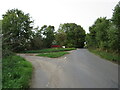
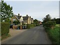
Whempstead Road, Whempstead, near Stevenage
Whempstead Road is a minor road passing through the hamlet of Whempstead in north Hertfordshire.
Image: © Malc McDonald
Taken: 25 Sep 2022
0.05 miles
3
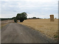
Track to Chapel Farm
Track forming route of bridleway as well as access to Chapel farm, which is visible in the centre. The crop has been harvested, baled and stacked.
Image: © Martin Addison
Taken: 6 Aug 2006
0.08 miles
4
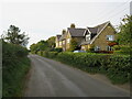
Whempstead Cottages, Whempstead, near Stevenage
Whempstead Cottages is a pair of semi-detached cottages in the small hamlet of Whempstead in north Hertfordshire.
Image: © Malc McDonald
Taken: 25 Sep 2022
0.10 miles
5
Whempstead Cottages, Whempstead, near Stevenage
Whempstead Cottages is a pair of semi-detached cottages in the small hamlet of Whempstead in north Hertfordshire.
Image: © Malc McDonald
Taken: 25 Sep 2022
0.11 miles