IMAGES TAKEN NEAR TO
Ware Park, WARE, SG12 0EB
Introduction
This page details the photographs taken nearby to Ware Park, SG12 0EB by members of the Geograph project.
The Geograph project started in 2005 with the aim of publishing, organising and preserving representative images for every square kilometre of Great Britain, Ireland and the Isle of Man.

There are currently over 7.5m images from over14,400 individuals and you can help contribute to the project by visiting https://www.geograph.org.uk
Image Map
Images are licensed for reuse under creativecommons.org/licenses/by-sa/2.0
Notes
- Clicking on the map will re-center to the selected point.
- The higher the marker number, the further away the image location is from the centre of the postcode.
Image Listing (5 Images Found)
Images are licensed for reuse under creativecommons.org/licenses/by-sa/2.0
Image
Details
Distance
2
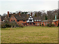
Carmelite Monastery
The Carmelite Nuns moved to this site in 1959. It is one of 16 Carmelite Monasteries in England. The Nuns are 'dedicated to prayers in silence and solitude'.
Image: © Melvyn Cousins
Taken: 13 Mar 2006
0.17 miles
3
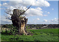
Tree Stump and A10
Not much life left in this old warrior now.
The A10 crosses the Lea valley in the distance. Good views from the path along this bit.
Image: © Des Blenkinsopp
Taken: 17 Sep 2010
0.21 miles
4
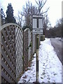
Pre-Worboys sign Ware Park
As the pole stops at the top of the sign this never actually had a triangle above it.
Image: © David Howard
Taken: 7 Feb 2009
0.23 miles
5
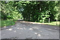
Ware Park Road
A private road serving the estate.
Image: © David Howard
Taken: 9 Jul 2023
0.24 miles