IMAGES TAKEN NEAR TO
Ware Park, WARE, SG12 0DY
Introduction
This page details the photographs taken nearby to Ware Park, SG12 0DY by members of the Geograph project.
The Geograph project started in 2005 with the aim of publishing, organising and preserving representative images for every square kilometre of Great Britain, Ireland and the Isle of Man.

There are currently over 7.5m images from over14,400 individuals and you can help contribute to the project by visiting https://www.geograph.org.uk
Image Map (Loading...)


Getting Data...Please wait
Leaflet Map data © OpenStreetMap
Images are licensed for reuse under creativecommons.org/licenses/by-sa/2.0
Notes
- Clicking on the map will re-center to the selected point.
- The higher the marker number, the further away the image location is from the centre of the postcode.
Image Listing (10 Images Found)
Images are licensed for reuse under creativecommons.org/licenses/by-sa/2.0
Image
Details
Distance
1
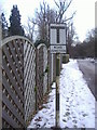
Pre-Worboys sign Ware Park
As the pole stops at the top of the sign this never actually had a triangle above it.
Image: © David Howard
Taken: 7 Feb 2009
0.01 miles
3
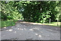
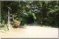
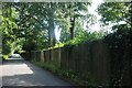
Ware Park Road
A private road serving the estate.
Image: © David Howard
Taken: 9 Jul 2023
0.03 miles
5
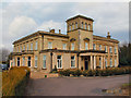
Ware Park Manor
This building and its grounds was originally a T.B. sanitarium but has been converted into luxury apartments.
Image: © Melvyn Cousins
Taken: 9 Mar 2006
0.08 miles
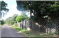
8
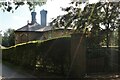
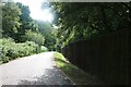
Lodge on Ware Park Road
This guards the private entrance.
Image: © David Howard
Taken: 9 Jul 2023
0.20 miles