IMAGES TAKEN NEAR TO
Canons Road, WARE, SG12 0BW
Introduction
This page details the photographs taken nearby to Canons Road, SG12 0BW by members of the Geograph project.
The Geograph project started in 2005 with the aim of publishing, organising and preserving representative images for every square kilometre of Great Britain, Ireland and the Isle of Man.

There are currently over 7.5m images from over14,400 individuals and you can help contribute to the project by visiting https://www.geograph.org.uk
Image Map (Loading...)


Getting Data...Please wait
Leaflet Map data © OpenStreetMap
Images are licensed for reuse under creativecommons.org/licenses/by-sa/2.0
Notes
- Clicking on the map will re-center to the selected point.
- The higher the marker number, the further away the image location is from the centre of the postcode.
Image Listing (20 Images Found)
Images are licensed for reuse under creativecommons.org/licenses/by-sa/2.0
Image
Details
Distance
1
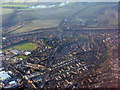
Western Ware
Looking along the B1004/A602 and their junction with the A10. The patches of water in the distance are by the River Rib.
Image: © M J Richardson
Taken: 6 Feb 2018
0.09 miles
9
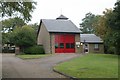
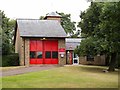
Ware fire station
Ware fire station, Baldock Street, Ware, Hertfordshire
Image: © Kevin Hale
Taken: 7 Oct 2007
0.18 miles
10
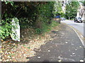
Old Milepost
Old milepost on what was the A10 at Ware, Hertfordshire; for close up view see http://www.geograph.org.uk/photo/3207523
Image: © Keith Evans
Taken: 1 Nov 2012
0.18 miles