IMAGES TAKEN NEAR TO
Lower Bourne Gardens, WARE, SG12 0BJ
Introduction
This page details the photographs taken nearby to Lower Bourne Gardens, SG12 0BJ by members of the Geograph project.
The Geograph project started in 2005 with the aim of publishing, organising and preserving representative images for every square kilometre of Great Britain, Ireland and the Isle of Man.

There are currently over 7.5m images from over14,400 individuals and you can help contribute to the project by visiting https://www.geograph.org.uk
Image Map
Images are licensed for reuse under creativecommons.org/licenses/by-sa/2.0
Notes
- Clicking on the map will re-center to the selected point.
- The higher the marker number, the further away the image location is from the centre of the postcode.
Image Listing (17 Images Found)
Images are licensed for reuse under creativecommons.org/licenses/by-sa/2.0
Image
Details
Distance
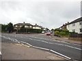
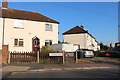
1
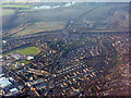
Western Ware
Looking along the B1004/A602 and their junction with the A10. The patches of water in the distance are by the River Rib.
Image: © M J Richardson
Taken: 6 Feb 2018
0.11 miles
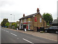
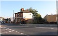
2
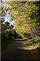
Poles Lane
A small lane now running through the Vicarage estate
Image: © John Webber
Taken: 2 Nov 2007
0.14 miles