IMAGES TAKEN NEAR TO
Hay Street, WARE, SG11 2RF
Introduction
This page details the photographs taken nearby to Hay Street, SG11 2RF by members of the Geograph project.
The Geograph project started in 2005 with the aim of publishing, organising and preserving representative images for every square kilometre of Great Britain, Ireland and the Isle of Man.

There are currently over 7.5m images from over14,400 individuals and you can help contribute to the project by visiting https://www.geograph.org.uk
Image Map (Loading...)


Getting Data...Please wait
Leaflet Map data © OpenStreetMap
Images are licensed for reuse under creativecommons.org/licenses/by-sa/2.0
Notes
- Clicking on the map will re-center to the selected point.
- The higher the marker number, the further away the image location is from the centre of the postcode.
Image Listing (10 Images Found)
Images are licensed for reuse under creativecommons.org/licenses/by-sa/2.0
Image
Details
Distance
1

30 limit though Hay Street
The B1368 heads to Hare Street and points north.
Image: © Robin Webster
Taken: 17 Feb 2019
0.03 miles
2
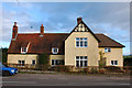
The Ex Adam & Eve P.H.
Would you 'Adam and Eve it' this private house on the main road in Hay Street used to be a Greene King pub.
Image: © Melvyn Cousins
Taken: 4 Jan 2007
0.04 miles
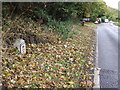
3
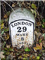
Old Milestone
Old milestone on the B1368 near to Hay Street, Hertfordshire. For overall view see http://www.geograph.org.uk/photo/3206784
Image: © Keith Evans
Taken: 1 Nov 2012
0.18 miles
4
Old Milestone by the B1368, Hay Street, Braughing
Carved stone post by the B1368, in parish of BRAUGHING (EAST HERTFORDSHIRE District), Hay Street, Braughing, South of Hay Cottage, almost buried on the verge, on West side of road. Wadesmill plate, erected by the Wadesmill turnpike trust in the 19th century.
Inscription reads:-
LONDON
129
WARE
8
BARKWAY
6
Listed HHER Number: 5050 https://www.heritagegateway.org.uk/Gateway/Results_Single.aspx?uid=MHT5050&resourceID=1008
Milestone Society National ID: HE_LKX29.
Image: © MW Hallett
Taken: 18 Aug 2002
0.18 miles
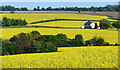
5
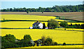
Oilseed Rape fields near Hay Street, Hertfordshire
Looking east with Quinbury Farm in the centre.
Image: © Christine Matthews
Taken: 23 May 2010
0.18 miles
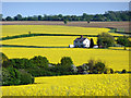
6
Oilseed Rape fields near Hay Street, Hertfordshire
Looking east from the B1368.
Image: © Christine Matthews
Taken: 23 May 2010
0.18 miles
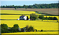
7
Quinbury Farm near Hay Street, Hertfordshire
Looking across from the B1368.
Image: © Christine Matthews
Taken: 23 May 2010
0.18 miles
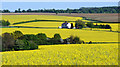
8
Quinbury Farm near Hay Street, Hertfordshire
Looking across the oilseed rape fields towards Quinbury Farm.
Image: © Christine Matthews
Taken: 23 May 2010
0.18 miles
9
Oilseed Rape fields near Hay Street, Hertfordshire
Looking across from the B1368.
Image: © Christine Matthews
Taken: 23 May 2010
0.20 miles
10
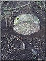
Old Milestone
Old milestone on the B1368 near to Hay Street, Hertfordshire. For close up view see http://www.geograph.org.uk/photo/3206788
Image: © Keith Evans
Taken: 1 Nov 2012
0.22 miles