IMAGES TAKEN NEAR TO
Patmore Heath, WARE, SG11 2LX
Introduction
This page details the photographs taken nearby to Patmore Heath, SG11 2LX by members of the Geograph project.
The Geograph project started in 2005 with the aim of publishing, organising and preserving representative images for every square kilometre of Great Britain, Ireland and the Isle of Man.

There are currently over 7.5m images from over14,400 individuals and you can help contribute to the project by visiting https://www.geograph.org.uk
Image Map (Loading...)


Getting Data...Please wait
Leaflet Map data © OpenStreetMap
Images are licensed for reuse under creativecommons.org/licenses/by-sa/2.0
Notes
- Clicking on the map will re-center to the selected point.
- The higher the marker number, the further away the image location is from the centre of the postcode.
Image Listing (10 Images Found)
Images are licensed for reuse under creativecommons.org/licenses/by-sa/2.0
Image
Details
Distance
1
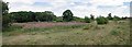
Patmore Heath Panorama
Image is an SSSI in the care of Hertfordshire and Middlesex Wildlife Trust https://www.hertswildlifetrust.org.uk/nature-reserves/patmore-heath?gclid=EAIaIQobChMI44fbjtr06gIVl-7tCh3CaQymEAAYASAAEgJ1CfD_BwE
Image: © Glyn Baker
Taken: 29 Jul 2020
0.10 miles
2
Patmore Heath
One of the few remaining patches of acid heathland in Southeast England this SSSI in the care of the Hertfordshire and Middlesex Wildlife Trust https://www.hertswildlifetrust.org.uk/nature-reserves/patmore-heath?gclid=EAIaIQobChMI44fbjtr06gIVl-7tCh3CaQymEAAYASAAEgJ1CfD_BwE
Image: © Glyn Baker
Taken: 29 Jul 2020
0.11 miles
3
Cottage by Patmore Heath
The cottage stands by Image an SSSI in the care of Hertfordshire and Middlesex Wildlife Trust https://www.hertswildlifetrust.org.uk/nature-reserves/patmore-heath?gclid=EAIaIQobChMI44fbjtr06gIVl-7tCh3CaQymEAAYASAAEgJ1CfD_BwE
Image: © Glyn Baker
Taken: 29 Jul 2020
0.12 miles
4
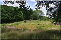
Patmore Heath Scene
Image is an SSSI in the care of Hertfordshire and Middlesex Wildlife Trust https://www.hertswildlifetrust.org.uk/nature-reserves/patmore-heath?gclid=EAIaIQobChMI44fbjtr06gIVl-7tCh3CaQymEAAYASAAEgJ1CfD_BwE
Image: © Glyn Baker
Taken: 29 Jul 2020
0.12 miles
5
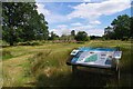
Patmore Heath
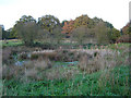
Patmore Heath is an example of grass heathland, now a scarce habitat in the south east of England. The heath is an SSSI, managed by The Herts and Middlesex Wildlife Trust, and covers about 9 hectares. There are several ponds, the southernmost of which is viewed here. http://www.wildlifetrust.org.uk/herts/reserves/patmore%20heath.htm for further information.
Image: © Nigel Cox
Taken: 19 Nov 2005
0.14 miles
6
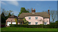
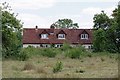
Cottage
Striking pink cottage in Patmore Heath
Image: © Iain Simpson
Taken: 19 Apr 2009
0.20 miles
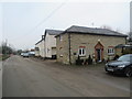
8
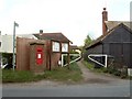
Houses at High Hall
The near house with the interesting brickwork is The Old Stables. The next has 'High Hall' on the wall, but that is the name of the big house across the road behind the camera, so perhaps the white house is High Hall cottage.
Image: © Robin Webster
Taken: 13 Mar 2014
0.24 miles
9
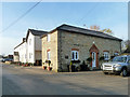
Albury Road, Clapgate, near Albury
Albury Road passing through the hamlet of Clapgate in rural north Hertfordshire.
Image: © Malc McDonald
Taken: 25 Jan 2020
0.25 miles
10
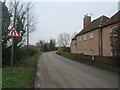
Albury Road, Clapgate, near Albury
Albury Road passing through the hamlet of Clapgate in north Hertfordshire.
Image: © Malc McDonald
Taken: 25 Jan 2020
0.25 miles