IMAGES TAKEN NEAR TO
Albury End, WARE, SG11 2HR
Introduction
This page details the photographs taken nearby to Albury End, SG11 2HR by members of the Geograph project.
The Geograph project started in 2005 with the aim of publishing, organising and preserving representative images for every square kilometre of Great Britain, Ireland and the Isle of Man.

There are currently over 7.5m images from over14,400 individuals and you can help contribute to the project by visiting https://www.geograph.org.uk
Image Map
Images are licensed for reuse under creativecommons.org/licenses/by-sa/2.0
Notes
- Clicking on the map will re-center to the selected point.
- The higher the marker number, the further away the image location is from the centre of the postcode.
Image Listing (2 Images Found)
Images are licensed for reuse under creativecommons.org/licenses/by-sa/2.0
Image
Details
Distance
1
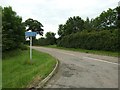
The road to Albury End from Stane Street
Image: © Jeff Tomlinson
Taken: 21 Jun 2007
0.06 miles
2
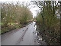
Albury: The lane to Albury End
The name of this lane that connects Albury End with Stane Street is not shown on any readily available maps or satellite imagery, but speculatively is Albury End Lane!
Image: © Nigel Cox
Taken: 19 Jan 2014
0.19 miles