IMAGES TAKEN NEAR TO
Bury Green, WARE, SG11 2HF
Introduction
This page details the photographs taken nearby to Bury Green, SG11 2HF by members of the Geograph project.
The Geograph project started in 2005 with the aim of publishing, organising and preserving representative images for every square kilometre of Great Britain, Ireland and the Isle of Man.

There are currently over 7.5m images from over14,400 individuals and you can help contribute to the project by visiting https://www.geograph.org.uk
Image Map
Images are licensed for reuse under creativecommons.org/licenses/by-sa/2.0
Notes
- Clicking on the map will re-center to the selected point.
- The higher the marker number, the further away the image location is from the centre of the postcode.
Image Listing (4 Images Found)
Images are licensed for reuse under creativecommons.org/licenses/by-sa/2.0
Image
Details
Distance
1
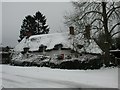
Clintons
Farm and stables at the south end of Bury Green
Image: © John Smith
Taken: 12 Sep 2006
0.12 miles
2
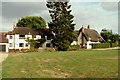
Cottages at Bury Green, near Little Hadham, Herts.
Image: © Robert Edwards
Taken: 9 Aug 2006
0.13 miles
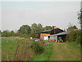
3
Farm Place, Bury Green
A large complex of buildings, with presumably some history; apparently GlaxoSmithKline used to own Bury Green Farm. They built a number of specialist buildings including some used to rear animals for medical research. GSK left the site in 2003. Now being turned into 'Exclusive lifestyle homes within a haven of rural ambience'.
Image: © M J Richardson
Taken: 5 Jul 2018
0.13 miles