IMAGES TAKEN NEAR TO
Sadlier Road, WARE, SG11 1PU
Introduction
This page details the photographs taken nearby to Sadlier Road, SG11 1PU by members of the Geograph project.
The Geograph project started in 2005 with the aim of publishing, organising and preserving representative images for every square kilometre of Great Britain, Ireland and the Isle of Man.

There are currently over 7.5m images from over14,400 individuals and you can help contribute to the project by visiting https://www.geograph.org.uk
Image Map
Images are licensed for reuse under creativecommons.org/licenses/by-sa/2.0
Notes
- Clicking on the map will re-center to the selected point.
- The higher the marker number, the further away the image location is from the centre of the postcode.
Image Listing (5 Images Found)
Images are licensed for reuse under creativecommons.org/licenses/by-sa/2.0
Image
Details
Distance
2
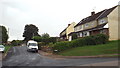
Batchelors, Standon
Batchelors is a residential cul-de-sac in the Hertfordshire village of Standon.
Image: © Malc McDonald
Taken: 3 Aug 2013
0.10 miles
3
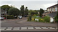
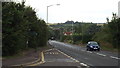
Barwick Road meets the A120
A crossroads, South Road continues north.
Image: © Robin Webster
Taken: 17 Feb 2019
0.12 miles
4
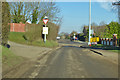
A120 road at Standon
The A120 road passing through Standon in Hertfordshire.
Image: © Malc McDonald
Taken: 3 Aug 2013
0.13 miles
5
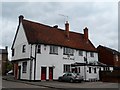
The Crown and Falcon pub, Puckeridge
Built in C16 and restored in C19. See http://www.britishlistedbuildings.co.uk/en-161080-crown-and-falcon-public-house-standon-he#.VWSj6s9Viko for entry in British Listed Buildings.
Image: © Bikeboy
Taken: 25 May 2015
0.24 miles