IMAGES TAKEN NEAR TO
Hadham Road, WARE, SG11 1LF
Introduction
This page details the photographs taken nearby to Hadham Road, SG11 1LF by members of the Geograph project.
The Geograph project started in 2005 with the aim of publishing, organising and preserving representative images for every square kilometre of Great Britain, Ireland and the Isle of Man.

There are currently over 7.5m images from over14,400 individuals and you can help contribute to the project by visiting https://www.geograph.org.uk
Image Map
Images are licensed for reuse under creativecommons.org/licenses/by-sa/2.0
Notes
- Clicking on the map will re-center to the selected point.
- The higher the marker number, the further away the image location is from the centre of the postcode.
Image Listing (42 Images Found)
Images are licensed for reuse under creativecommons.org/licenses/by-sa/2.0
Image
Details
Distance
1
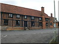
Knight's Court, Standon
A manorial courthouse from the 16thC or earlier. It was a school from 1610 to 1980 but has now been converted to 4 dwellings.
Image: © Eirian Evans
Taken: 18 Jul 2012
0.03 miles
2
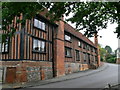
Knight's Court, Standon
Another view of Knight's Court Image
Image: © Eirian Evans
Taken: 18 Jul 2012
0.05 miles
3
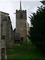
St Mary's Church, Standon
The bell tower stands alone, next to the church.
Image: © Eirian Evans
Taken: 18 Jul 2012
0.05 miles
4
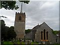
St Mary's Standon
This is the only church in Hertfordshire with a detached tower. The chancel is C13. The tower is C15. The church was restored in 1864. Inside there is a monument to Sir Ralph Sadlier, Principal Secretary to Henry VIII and resident of the nearby Lordship. See http://www.geograph.org.uk/photo/4493109 .
Image: © Bikeboy
Taken: 25 May 2015
0.06 miles
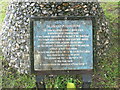
5
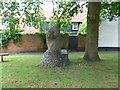
Standon Puddingstone
This stone looks like a palaeolithic venus figure. Situated opposite the church on the junction of the High Street and Paper Mill Lane, it is garlanded on May Day when the villagers commence a procession and hold their fete in the main street. Next to it is an oak planted to commemorate the coronation of King George V.
Image: © Eirian Evans
Taken: 18 Jul 2012
0.06 miles
6
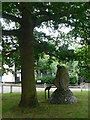
Standon Puddingstone
This stone looks like a palaeolithic venus figure. Situated opposite the church on the junction of the High Street and Paper Mill Lane, it is garlanded on May Day when the villagers commence a procession and hold their fete in the main street. Next to it is an oak planted to commemorate the coronation of King George V.
Image: © Eirian Evans
Taken: 18 Jul 2012
0.06 miles
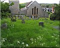
8
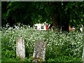
Cow Parsley and gravestones, St Mary's Standon
Image: © Bikeboy
Taken: 25 May 2015
0.07 miles
10

Standon church
St. Mary's is a grade I listed building, mainly 14th and 15th centuries.
Image: © Robin Webster
Taken: 17 Feb 2019
0.07 miles