IMAGES TAKEN NEAR TO
Old Hall Green, WARE, SG11 1DN
Introduction
This page details the photographs taken nearby to SG11 1DN by members of the Geograph project.
The Geograph project started in 2005 with the aim of publishing, organising and preserving representative images for every square kilometre of Great Britain, Ireland and the Isle of Man.

There are currently over 7.5m images from over14,400 individuals and you can help contribute to the project by visiting https://www.geograph.org.uk
Image Map (Loading...)


Getting Data...Please wait
Leaflet Map data © OpenStreetMap
Images are licensed for reuse under creativecommons.org/licenses/by-sa/2.0
Notes
- Clicking on the map will re-center to the selected point.
- The higher the marker number, the further away the image location is from the centre of the postcode.
Image Listing (10 Images Found)
Images are licensed for reuse under creativecommons.org/licenses/by-sa/2.0
Image
Details
Distance
1
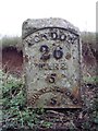
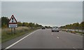
Old Milestone by the A10, north of Ryders Grove, Standon parish
Metal plate attached to stone post by the A10, in parish of Standon (East Hertfordshire District), North of Ryders Grove, on the verge, on East side of road. Wadesmill plate, erected by the Wadesmill turnpike trust in the 19th century.
Inscription reads:-
LONDON
26
WARE
5
BUNTINGFORD
5
Carved benchmark on left face, rivet on top.
Grade II listed.
List Entry Number: 1347467 https://historicengland.org.uk/listing/the-list/list-entry/1347467
Milestone Society National ID: HE_LK26
Image: © MW Hallett
Taken: 11 Aug 2002
0.10 miles
2
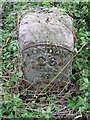
Old Milestone
Old milestone on what was the A.10 near to Puckeridge, Hertfordshire for overall view see http://www.geograph.org.uk/photo/3650901
Image: © Keith Evans
Taken: 11 Sep 2013
0.10 miles
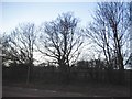
4
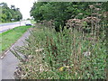
Old Milestone
Old milestone virtually hidden by weeds on what was the A.10 near to Puckeridge, Hertfordshire for close up view see http://www.geograph.org.uk/photo/3650904
Image: © Keith Evans
Taken: 11 Sep 2013
0.12 miles
7
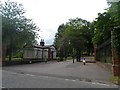
Entrance to St Edmund's College
St Edmund's college is a private Roman Catholic school.
Image: © Bikeboy
Taken: 21 Jun 2015
0.20 miles
9
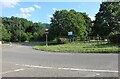
Junction on Ermine Street, Standon
By St Edmund's College
Image: © David Howard
Taken: 9 Jul 2023
0.22 miles
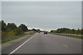
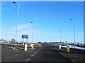
10
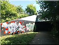
Subway under the A10
This is a new section of the A10 dating from the mid 90's. The old A10 runs alongside.
Image: © Bikeboy
Taken: 29 Jun 2024
0.23 miles