IMAGES TAKEN NEAR TO
Clements Close, WARE, SG11 1DE
Introduction
This page details the photographs taken nearby to Clements Close, SG11 1DE by members of the Geograph project.
The Geograph project started in 2005 with the aim of publishing, organising and preserving representative images for every square kilometre of Great Britain, Ireland and the Isle of Man.

There are currently over 7.5m images from over14,400 individuals and you can help contribute to the project by visiting https://www.geograph.org.uk
Image Map (Loading...)


Getting Data...Please wait
Leaflet Map data © OpenStreetMap
Images are licensed for reuse under creativecommons.org/licenses/by-sa/2.0
Notes
- Clicking on the map will re-center to the selected point.
- The higher the marker number, the further away the image location is from the centre of the postcode.
Image Listing (21 Images Found)
Images are licensed for reuse under creativecommons.org/licenses/by-sa/2.0
Image
Details
Distance
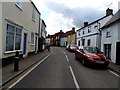
4

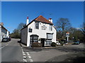
'The White Hart' inn on Buntingford Road
Image: © Robert Edwards
Taken: 29 Oct 2008
0.09 miles
5

"The White Hart" public house, Puckeridge
Grade II listed public house, described at this https://historicengland.org.uk/listing/the-list/list-entry/1102372.
Image: © Jim Osley
Taken: 11 Aug 2016
0.10 miles
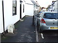
6
The White Hart Pub, Puckeridge
Built in C17. See http://www.britishlistedbuildings.co.uk/en-161073-the-white-hart-public-house-standon-hert#.Vvbd1OKLTIU for entry in British Listed Buildings
Image: © Bikeboy
Taken: 25 Mar 2016
0.10 miles
7
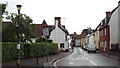
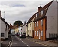
Puckeridge High Street
The High Street in the Hertfordshire village of Puckeridge.
Image: © Malc McDonald
Taken: 3 Aug 2013
0.11 miles
8
Old Milepost
Old milepost on what was the A.10 at Puckeridge, Hertfordshire for close up view see http://www.geograph.org.uk/photo/3207364
Image: © Keith Evans
Taken: 1 Nov 2012
0.13 miles
9
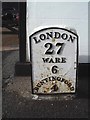
Old Milestone by High Street, Puckeridge
Metal plate attached to stone post by the UC road, in parish of STANDON (EAST HERTFORDSHIRE District), High Street, Puckeridge, by No. 16, in pavement, on West side of road. Wadesmill plate, erected by the Wadesmill turnpike trust in the 19th century.
Inscription reads:-
LONDON
27
WARE
6
BUNTINGFORD
4
Grade II listed. List Entry Number: 1102338
https://historicengland.org.uk/listing/the-list/list-entry/1102338
Milestone Society National ID: HE_LK27.
Image: © MW Hallett
Taken: 11 Aug 2002
0.14 miles