IMAGES TAKEN NEAR TO
South End, MUCH HADHAM, SG10 6EW
Introduction
This page details the photographs taken nearby to South End, SG10 6EW by members of the Geograph project.
The Geograph project started in 2005 with the aim of publishing, organising and preserving representative images for every square kilometre of Great Britain, Ireland and the Isle of Man.

There are currently over 7.5m images from over14,400 individuals and you can help contribute to the project by visiting https://www.geograph.org.uk
Image Map (Loading...)


Getting Data...Please wait
Leaflet Map data © OpenStreetMap
Images are licensed for reuse under creativecommons.org/licenses/by-sa/2.0
Notes
- Clicking on the map will re-center to the selected point.
- The higher the marker number, the further away the image location is from the centre of the postcode.
Image Listing (5 Images Found)
Images are licensed for reuse under creativecommons.org/licenses/by-sa/2.0
Image
Details
Distance
1
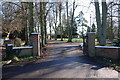
St Elizabeth's Centre
St Elizabeth's Centre is a school and home caring for people with epilepsy, and is now building a new residential wing to the centre.
Image: © Melvyn Cousins
Taken: 25 Jan 2007
0.01 miles
3
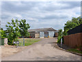
Barn at Old Park Farm
Viewed from the end of the public road, but a public footpath continues through the farmyard.
Image: © Robin Webster
Taken: 25 Jun 2015
0.18 miles
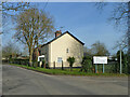
4
Minges
Minges farm is situated on a cul-de-sac road leading to Turtle Farm
Image: © John Smith
Taken: 13 Feb 2007
0.21 miles
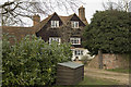
5
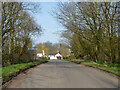
Entering Perry Green
On the road from Widford.
Image: © Robin Webster
Taken: 13 Mar 2014
0.22 miles