IMAGES TAKEN NEAR TO
Bourne Lane, MUCH HADHAM, SG10 6EU
Introduction
This page details the photographs taken nearby to Bourne Lane, SG10 6EU by members of the Geograph project.
The Geograph project started in 2005 with the aim of publishing, organising and preserving representative images for every square kilometre of Great Britain, Ireland and the Isle of Man.

There are currently over 7.5m images from over14,400 individuals and you can help contribute to the project by visiting https://www.geograph.org.uk
Image Map (4 Images)


Getting Data...Please wait
Leaflet Map data © OpenStreetMap
Images are licensed for reuse under creativecommons.org/licenses/by-sa/2.0
Notes
- Clicking on the map will re-center to the selected point.
- The higher the marker number, the further away the image location is from the centre of the postcode.
Image Listing (4 Images Found)
Images are licensed for reuse under creativecommons.org/licenses/by-sa/2.0
Image
Details
Distance
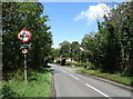
1
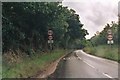
B1004 approaching Widford
Looking south on the approach to Widford.
Image: © Simon Davies
Taken: Unknown
0.14 miles
4
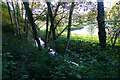
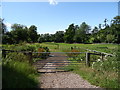
Hertfordshire Way footpath south of Much Hadham
The watercourse seen here is the River Ash which flows parallel to the footpath through Mill Wood.
Image: © David Kemp
Taken: 12 Nov 2022
0.25 miles