IMAGES TAKEN NEAR TO
MUCH HADHAM, SG10 6BD
Introduction
This page details the photographs taken nearby to SG10 6BD by members of the Geograph project.
The Geograph project started in 2005 with the aim of publishing, organising and preserving representative images for every square kilometre of Great Britain, Ireland and the Isle of Man.

There are currently over 7.5m images from over14,400 individuals and you can help contribute to the project by visiting https://www.geograph.org.uk
Image Map (Loading...)


Getting Data...Please wait
Leaflet Map data © OpenStreetMap
Images are licensed for reuse under creativecommons.org/licenses/by-sa/2.0
Notes
- Clicking on the map will re-center to the selected point.
- The higher the marker number, the further away the image location is from the centre of the postcode.
Image Listing (3 Images Found)
Images are licensed for reuse under creativecommons.org/licenses/by-sa/2.0
Image
Details
Distance
1

Chestnut flower
These amazing inflorescences can be taken for granted as the pink or white candles on the chestnut tree, but close-up they are beautiful!
Image: © Jonathan Billinger
Taken: 2 May 2007
0.17 miles
2
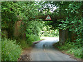
Old railway bridge over Blackbridge Lane
This was on the branch to Buntingford. The line closed in 1965, a year after passenger services finished.
Image: © Robin Webster
Taken: 25 Jun 2015
0.19 miles
3
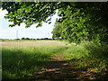
Footpath north from Blackbridge Lane
This is a way to Hadham Cross.
Image: © Robin Webster
Taken: 25 Jun 2015
0.19 miles