IMAGES TAKEN NEAR TO
MUCH HADHAM, SG10 6AA
Introduction
This page details the photographs taken nearby to SG10 6AA by members of the Geograph project.
The Geograph project started in 2005 with the aim of publishing, organising and preserving representative images for every square kilometre of Great Britain, Ireland and the Isle of Man.

There are currently over 7.5m images from over14,400 individuals and you can help contribute to the project by visiting https://www.geograph.org.uk
Image Map (Loading...)


Getting Data...Please wait
Leaflet Map data © OpenStreetMap
Images are licensed for reuse under creativecommons.org/licenses/by-sa/2.0
Notes
- Clicking on the map will re-center to the selected point.
- The higher the marker number, the further away the image location is from the centre of the postcode.
Image Listing (3 Images Found)
Images are licensed for reuse under creativecommons.org/licenses/by-sa/2.0
Image
Details
Distance
1
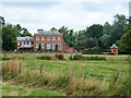
Moor Place, Much Hadham
A grade I listed building built 1775 - 1779. The garden wall and the pavilion at its right end are grade II listed, much later, 1938. There is another similar pavilion out of shot at its left end.
Image: © Robin Webster
Taken: 1 Aug 2015
0.01 miles
2
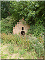
Small building, Moor Place
This little structure, curiously half in and half out of the boundary of the grounds of Moor Place, dates from before 1879 according to available maps, and looks considerably older. It has never been mapped with any description. It houses a well or sump with a square wooden cover, and the remains of a hand pump to raise water from it. See Image
Image: © Robin Webster
Taken: 1 Aug 2015
0.16 miles
3
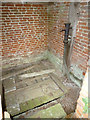
Inside small building near Moor Place
For an external view, see Image The pump lacks the moving parts.
Image: © Robin Webster
Taken: 1 Aug 2015
0.16 miles