IMAGES TAKEN NEAR TO
Wendover Road, LONDON, SE9 6PD
Introduction
This page details the photographs taken nearby to Wendover Road, SE9 6PD by members of the Geograph project.
The Geograph project started in 2005 with the aim of publishing, organising and preserving representative images for every square kilometre of Great Britain, Ireland and the Isle of Man.

There are currently over 7.5m images from over14,400 individuals and you can help contribute to the project by visiting https://www.geograph.org.uk
Image Map
Images are licensed for reuse under creativecommons.org/licenses/by-sa/2.0
Notes
- Clicking on the map will re-center to the selected point.
- The higher the marker number, the further away the image location is from the centre of the postcode.
Image Listing (43 Images Found)
Images are licensed for reuse under creativecommons.org/licenses/by-sa/2.0
Image
Details
Distance
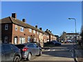
1
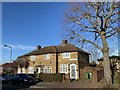
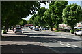
Bournbrook Road
Houses in Bournbrook Road.
Image: © Alan Hughes
Taken: 19 Jan 2020
0.07 miles
2
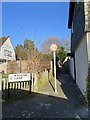
Kakehill Lane
Remains of an old lane which ran from Woolwich Road to the Old Dover Road (Watling Street).
Image: © Alan Hughes
Taken: 19 Jan 2020
0.14 miles
4
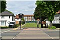
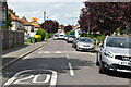
Whinyates Road, Eltham
Whinyates Road is a residential road in the south east London suburbs.
Image: © Malc McDonald
Taken: 14 Jul 2019
0.15 miles
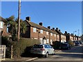
9
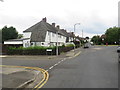
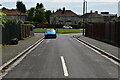
Langbrook Road
Housing in Langbrook Road.
Image: © Alan Hughes
Taken: 19 Jan 2020
0.19 miles
10
Langbrook Road
Housing in Langbrook Road.
Image: © Alan Hughes
Taken: 19 Jan 2020
0.19 miles