IMAGES TAKEN NEAR TO
Sherard Road, LONDON, SE9 6EP
Introduction
This page details the photographs taken nearby to Sherard Road, SE9 6EP by members of the Geograph project.
The Geograph project started in 2005 with the aim of publishing, organising and preserving representative images for every square kilometre of Great Britain, Ireland and the Isle of Man.

There are currently over 7.5m images from over14,400 individuals and you can help contribute to the project by visiting https://www.geograph.org.uk
Image Map
Images are licensed for reuse under creativecommons.org/licenses/by-sa/2.0
Notes
- Clicking on the map will re-center to the selected point.
- The higher the marker number, the further away the image location is from the centre of the postcode.
Image Listing (147 Images Found)
Images are licensed for reuse under creativecommons.org/licenses/by-sa/2.0
Image
Details
Distance
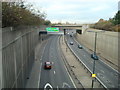
1

Sherard Road, Eltham
The road swings round a bend past the junction with Prince John Road. May in bloom.
Image: © Derek Harper
Taken: 20 May 2006
0.02 miles
4
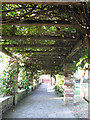
Wisteria, Eltham Pleasaunce
Another view of the Wisteria pergola shown in http://www.geograph.org.uk/search.php?i=25026511 , with the Italian garden beyond, and traffic and shops on Well Hall Road in the distance.
Image: © Derek Harper
Taken: 20 May 2006
0.08 miles
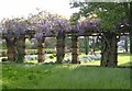
5
Young birches
These "silver" birches seemed to have particularly lustrous bark.
Image: © Stephen Craven
Taken: 15 Oct 2011
0.10 miles
6
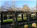
Underneath the pergola
Looking along the walkway under structure shown in Image
Image: © Stephen Craven
Taken: 15 Oct 2011
0.10 miles
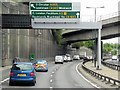
7
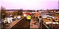
Eltham Well Hall station
A suburban electric multiple unit train arriving at Eltham Well Hall station in March 1985.
On the day after this image was taken, Eltham Well Hall station was closed permanently. It was replaced by a new station, Eltham, immediately to the east (visible in this image). Eltham station also replaced the next station along the line, Eltham Park.
The reason for replacing the stations was to allow the Rochester Way Relief Road to be built. Construction work on the new road is visible to the right of this image.
Image: © Malc McDonald
Taken: 16 Mar 1985
0.10 miles
8

Tattersall Close, Eltham
On the left is a T-shaped block of 80 flats. On the right is a day centre. Seen from the stretch of road shown in Image, looking to the right.
Image: © Derek Harper
Taken: 20 May 2006
0.11 miles
9
Pergola in Well Hall Pleasaunce
Well Hall Pleasaunce dates back to the 13th century. It contained a Manor House at the time of Henry VIII and more recently was the home of the author of The Railway Children Edith Nesbit. The Manor House has gone although the moat survives as does The Tudor Barn. Well Hall Pleasaunce consists of a series of formal gardens, ponds and woodland, and has recently undergone an extensive restoration.
The main trunk of the wisteria which covers the pergola can be seen in the foreground. See also https://www.geograph.org.uk/photo/2391038
Image: © Marathon
Taken: 22 Jan 2021
0.11 miles
10
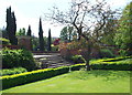
Well Hall Pleasaunce, Eltham SE9
Different levels of horticultural prowess appear to be demonstrated here. Edith Nesbit Walk (named after the author of the children's book: "The Railway Children") is situated beyond a run of iron boundary railings in the distance.
Image: © David Hallam-Jones
Taken: 4 May 2014
0.11 miles