IMAGES TAKEN NEAR TO
Horsfeld Road, LONDON, SE9 6DS
Introduction
This page details the photographs taken nearby to Horsfeld Road, SE9 6DS by members of the Geograph project.
The Geograph project started in 2005 with the aim of publishing, organising and preserving representative images for every square kilometre of Great Britain, Ireland and the Isle of Man.

There are currently over 7.5m images from over14,400 individuals and you can help contribute to the project by visiting https://www.geograph.org.uk
Image Map
Images are licensed for reuse under creativecommons.org/licenses/by-sa/2.0
Notes
- Clicking on the map will re-center to the selected point.
- The higher the marker number, the further away the image location is from the centre of the postcode.
Image Listing (46 Images Found)
Images are licensed for reuse under creativecommons.org/licenses/by-sa/2.0
Image
Details
Distance
1
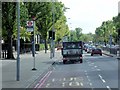
Traffic lights on Westhorne Avenue
This is part of the South Circular Road, about to go under a railway and the A2.
Image: © Bill Boaden
Taken: 11 Oct 2014
0.07 miles
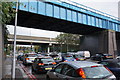
2
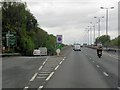
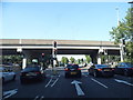
A205 Westhorne Avenue
The blue bridge in the background carries the railway over the South Circular Road. It hides an adjacent bridge which carries the A2.
Image: © David Martin
Taken: 19 Jan 2020
0.07 miles
3
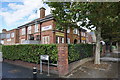
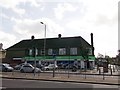
Real Life Church, Eltham
It describes itself as non-denominational and multi-national.
Image: © Bill Boaden
Taken: 11 Oct 2014
0.08 miles
4
A2 Red Route Clearway
London's red routes are intended to reduce traffic congestion on major roads. Vehicles are not permitted to stop on red routes. This prohibition extends to stopping for loading or unloading, and to boarding or alighting from a vehicle (except for licensed taxis and the holders of blue badges http://goo.gl/PXpxI Direct.gov Road Markings). Red routes are mainly used on major bus and commuting routes. They form a network that makes up 5 per cent of the roads, but carry up to 30 per cent of the city's traffic.
Red routes are marked with red lines at the sides of the road. Double red lines mean that the regulations apply at all times and on all days. Single red lines means that the prohibition applies during times displayed on nearby signs or at the entry to the zone. Red route clearways are signed but there are no lines on the road. Stopping is only permitted in lay-bys.
A similar red route scheme is in use in the West Midlands
Image: © David Dixon
Taken: 15 May 2013
0.09 miles
6
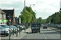
The Co-operative Supermarket, Eltham
On the A205 Westhorne Avenue. Beside Haimo Road.
Image: © David Anstiss
Taken: 11 Sep 2011
0.09 miles
7
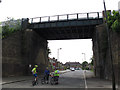
Railway bridge over Foxhole Road
The railway line is Charing Cross-Dartford via Eltham. The road is a dead end - for a view in the opposite direction at this point see Image
Image: © Stephen Craven
Taken: 5 May 2014
0.09 miles
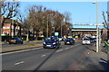
8
Westhorne Avenue at the junction with the A2
Image: © David Howard
Taken: 18 May 2014
0.10 miles
9
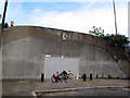
Foxhole underpass, blocked
This pedestrian/cyclist underpass beneath the A2 dual carriageway used to be a useful link Image but was closed in 2011 apparently because of antisocial behaviour.
Image: © Stephen Craven
Taken: 5 May 2014
0.10 miles