IMAGES TAKEN NEAR TO
Ealdham Square, LONDON, SE9 6BP
Introduction
This page details the photographs taken nearby to Ealdham Square, SE9 6BP by members of the Geograph project.
The Geograph project started in 2005 with the aim of publishing, organising and preserving representative images for every square kilometre of Great Britain, Ireland and the Isle of Man.

There are currently over 7.5m images from over14,400 individuals and you can help contribute to the project by visiting https://www.geograph.org.uk
Image Map (Loading...)


Getting Data...Please wait
Leaflet Map data © OpenStreetMap
Images are licensed for reuse under creativecommons.org/licenses/by-sa/2.0
Notes
- Clicking on the map will re-center to the selected point.
- The higher the marker number, the further away the image location is from the centre of the postcode.
Image Listing (61 Images Found)
Images are licensed for reuse under creativecommons.org/licenses/by-sa/2.0
Image
Details
Distance
1

Ealdham Primary School
The school featured in Jamie's School Dinners in 2005.
Image: © Derek Harper
Taken: 20 May 2006
0.04 miles
2
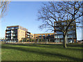
Kidbrooke Village: Campbell Court
One of four blocks on a new road called Meadowside in the first phase of the new development, each of these blocks is 3-sided.
Image: © Stephen Craven
Taken: 24 Jan 2015
0.13 miles
3
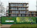
New apartments at Sutcliffe Park
A long block of apartments being built on what had been a sports field, viewed from adjacent Sutcliffe Park.
Image: © Stephen Craven
Taken: 20 Jun 2010
0.15 miles
4
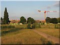
Kidbrooke Regeneration
A hoarding and building under construction viewed from Sutcliffe Park. Most of the 'Kidbrooke Regeneration' involved demolishing 1960s housing and replacing, but this area was building on part of the park.
Image: © Robin Webster
Taken: 4 Feb 2012
0.16 miles
5
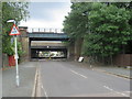
Shawbrooke Road, near Eltham
Bridges across Shawbrooke Road near Eltham in south east London. The bridge nearest the camera carries a railway line. The concrete bridge behind it carries the trunk A2 road.
The road bridge has a height limit of 12 feet, as indicated by the warning signs. There is also a width restriction near the bridge, to prevent lorries from using this road.
Image: © Malc McDonald
Taken: 14 Jul 2019
0.17 miles
6
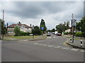
Shawbrooke Road, near Eltham
Shawbrooke Road is a residential road near Eltham, in the suburbs of south east London.
Image: © Malc McDonald
Taken: 14 Jul 2019
0.17 miles
8

Freeman Walk
These blocks of housing are phase 1 of the extensive Kidbrooke estate redevelopment. So new that at the time of submission the development was not shown on online mapping, hence the location is only approximate.
Image: © Stephen Craven
Taken: 2 Oct 2011
0.17 miles
9
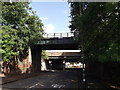
Railway bridge on Shawbrooke Road
Shawbrooke Road leads from Elham Green Road towards Briset Road .
It passes under the railway between Kidbrooke and Eltham.
In the background is Image, which follows the railway for a section.
Image: © David Anstiss
Taken: 11 Sep 2011
0.18 miles
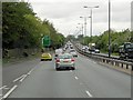
10

Eltham Green Road
The blocks of housing on the left are phase 1 of the extensive Kidbrooke estate redevelopment. So new that at the time of submission the development was not shown on online mapping.
Image: © Stephen Craven
Taken: 2 Oct 2011
0.18 miles