IMAGES TAKEN NEAR TO
Philippa Gardens, LONDON, SE9 6AP
Introduction
This page details the photographs taken nearby to Philippa Gardens, SE9 6AP by members of the Geograph project.
The Geograph project started in 2005 with the aim of publishing, organising and preserving representative images for every square kilometre of Great Britain, Ireland and the Isle of Man.

There are currently over 7.5m images from over14,400 individuals and you can help contribute to the project by visiting https://www.geograph.org.uk
Image Map
Images are licensed for reuse under creativecommons.org/licenses/by-sa/2.0
Notes
- Clicking on the map will re-center to the selected point.
- The higher the marker number, the further away the image location is from the centre of the postcode.
Image Listing (47 Images Found)
Images are licensed for reuse under creativecommons.org/licenses/by-sa/2.0
Image
Details
Distance
1
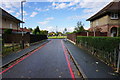
Philippa Gardens, Eltham
A housing area with a green space in the middle.
Image: © Bill Boaden
Taken: 11 Oct 2014
0.04 miles
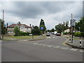
2

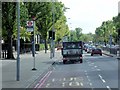
A205 near Eltham Green
The dual carriageway approaches the Eltham Green Roundabout, seen from the junction with Lionel Road.
Image: © Derek Harper
Taken: 20 May 2006
0.06 miles
3

A205 near Eltham Green
The stretch of dual carriageway shown in Image from the other side of the road, with signs warning of the Eltham Green Roundabout.
Image: © Derek Harper
Taken: 20 May 2006
0.08 miles
4

Keeling Road
A narrow one-way residential road off the South Circular Road.
Image: © Bill Boaden
Taken: 11 Oct 2014
0.09 miles
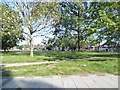
6
Shawbrooke Road, near Eltham
Shawbrooke Road is a residential road near Eltham, in the suburbs of south east London.
Image: © Malc McDonald
Taken: 14 Jul 2019
0.13 miles
7
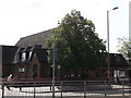
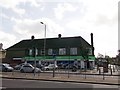
Elham Green Community Church
On the junction of the A205 Westhorne Avenue (in front) and Haimo Road (on the left).
Image: © David Anstiss
Taken: 11 Sep 2011
0.13 miles
9

Eltham Green Road
The blocks of housing on the left are phase 1 of the extensive Kidbrooke estate redevelopment. So new that at the time of submission the development was not shown on online mapping.
Image: © Stephen Craven
Taken: 2 Oct 2011
0.14 miles
10
The Co-operative Supermarket, Eltham
On the A205 Westhorne Avenue. Beside Haimo Road.
Image: © David Anstiss
Taken: 11 Sep 2011
0.15 miles