IMAGES TAKEN NEAR TO
Eltham Hill, LONDON, SE9 5EF
Introduction
This page details the photographs taken nearby to Eltham Hill, SE9 5EF by members of the Geograph project.
The Geograph project started in 2005 with the aim of publishing, organising and preserving representative images for every square kilometre of Great Britain, Ireland and the Isle of Man.

There are currently over 7.5m images from over14,400 individuals and you can help contribute to the project by visiting https://www.geograph.org.uk
Image Map
Images are licensed for reuse under creativecommons.org/licenses/by-sa/2.0
Notes
- Clicking on the map will re-center to the selected point.
- The higher the marker number, the further away the image location is from the centre of the postcode.
Image Listing (22 Images Found)
Images are licensed for reuse under creativecommons.org/licenses/by-sa/2.0
Image
Details
Distance

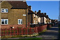
2

Keynsham Road, Eltham
At the junction with Keynsham Gardens.
Image: © Derek Harper
Taken: 20 May 2006
0.10 miles
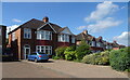
3
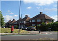
Houses on Green Way
Showing position of Postbox No. SE9 26.
See Image] for postbox.
Image: © JThomas
Taken: 24 Jun 2022
0.11 miles
4
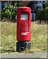
Elizabeth II postbox on Eltham Hill
Postbox No. SE9 26.
See Image] for context.
Image: © JThomas
Taken: 24 Jun 2022
0.12 miles
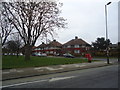
5

Roundabout , Eltham
Where five suburban roads meet. Prince John Road is ahead; to the right is Keynsham Road.
Image: © Derek Harper
Taken: 20 May 2006
0.12 miles
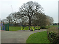
7
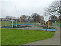
Children's play area
In Queenscroft recreation ground.
Image: © Robin Webster
Taken: 4 Feb 2012
0.13 miles
10
Exercise apparatus, Queenscroft recreation ground
The apparatus looks very new.
Image: © Robin Webster
Taken: 4 Feb 2012
0.14 miles