IMAGES TAKEN NEAR TO
Kippington Drive, LONDON, SE9 4RG
Introduction
This page details the photographs taken nearby to Kippington Drive, SE9 4RG by members of the Geograph project.
The Geograph project started in 2005 with the aim of publishing, organising and preserving representative images for every square kilometre of Great Britain, Ireland and the Isle of Man.

There are currently over 7.5m images from over14,400 individuals and you can help contribute to the project by visiting https://www.geograph.org.uk
Image Map
Images are licensed for reuse under creativecommons.org/licenses/by-sa/2.0
Notes
- Clicking on the map will re-center to the selected point.
- The higher the marker number, the further away the image location is from the centre of the postcode.
Image Listing (56 Images Found)
Images are licensed for reuse under creativecommons.org/licenses/by-sa/2.0
Image
Details
Distance
1
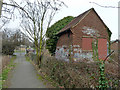
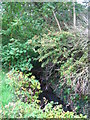
Small shuttered building
Probably to do with water - a stream issues nearby on maps, and before the building was built the stream issued about on this spot.
Image: © Robin Webster
Taken: 4 Feb 2012
0.04 miles
2
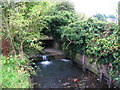
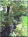
The Little Quaggy north of Kippington Drive, SE9
This seems to be the furthest point east that the Little Quaggy is visible above ground. The stream is fed from the Image
Image: © Mike Quinn
Taken: 23 Sep 2010
0.05 miles
4
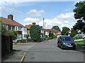
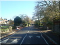
Public footpath, Mottingham
A public footpath leading northwards from Mottingham Lane.
Image: © Malc McDonald
Taken: 19 Mar 2011
0.07 miles
5
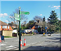
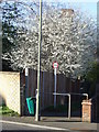
Green Chain Signpost, Mottingham Lane
The Green Chain Walks are a series of routes linking parks and woodlands and other open spaces around south east London.
Inevitably there is quite a bit of roadside walking, as along here, but major roads are avoided for the most part.
The way markers are definitely among the best of any LDP signage, with these solid green guideposts
all along the routes.
https://tfl.gov.uk/modes/walking/green-chain-walk
Image: © Des Blenkinsopp
Taken: 6 Mar 2020
0.09 miles
6
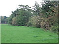
Grazing land between Sidcup Road (A20) and the Little Quaggy (3)
Image: © Mike Quinn
Taken: 23 Sep 2010
0.10 miles
10
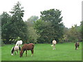
Horses grazing on land between Sidcup Road (A20) and the Little Quaggy
The stream runs in the trees behind the horses.
Image: © Mike Quinn
Taken: 28 Sep 2010
0.11 miles