IMAGES TAKEN NEAR TO
Prestbury Square, LONDON, SE9 4LZ
Introduction
This page details the photographs taken nearby to Prestbury Square, SE9 4LZ by members of the Geograph project.
The Geograph project started in 2005 with the aim of publishing, organising and preserving representative images for every square kilometre of Great Britain, Ireland and the Isle of Man.

There are currently over 7.5m images from over14,400 individuals and you can help contribute to the project by visiting https://www.geograph.org.uk
Image Map
Images are licensed for reuse under creativecommons.org/licenses/by-sa/2.0
Notes
- Clicking on the map will re-center to the selected point.
- The higher the marker number, the further away the image location is from the centre of the postcode.
Image Listing (47 Images Found)
Images are licensed for reuse under creativecommons.org/licenses/by-sa/2.0
Image
Details
Distance
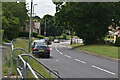
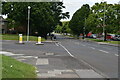
7
Footpath to Elmstead Lane, Mottingham
Image: © Malc McDonald
Taken: 19 Mar 2011
0.10 miles
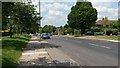
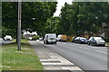
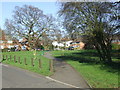
10
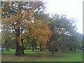
Wayside Grove
Wayside Grove is a strip of mature trees, next to the busy Elmstead Lane, which has been preserved in between the surrounding housing.
Image: © Marathon
Taken: 3 Nov 2010
0.12 miles