IMAGES TAKEN NEAR TO
Luxfield Road, LONDON, SE9 4EZ
Introduction
This page details the photographs taken nearby to Luxfield Road, SE9 4EZ by members of the Geograph project.
The Geograph project started in 2005 with the aim of publishing, organising and preserving representative images for every square kilometre of Great Britain, Ireland and the Isle of Man.

There are currently over 7.5m images from over14,400 individuals and you can help contribute to the project by visiting https://www.geograph.org.uk
Image Map
Images are licensed for reuse under creativecommons.org/licenses/by-sa/2.0
Notes
- Clicking on the map will re-center to the selected point.
- The higher the marker number, the further away the image location is from the centre of the postcode.
Image Listing (70 Images Found)
Images are licensed for reuse under creativecommons.org/licenses/by-sa/2.0
Image
Details
Distance
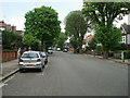
2
Substantial detached houses in West Park
Image: © David Martin
Taken: 21 Jun 2014
0.07 miles
5
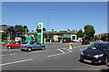
Petrol Garage in Mottingham
A previous iteration of this garage was hit by a V2 bomb in WW2. Took the roofs off most of the houses in the local.
Image: © Martin Kerans
Taken: 30 May 2009
0.15 miles
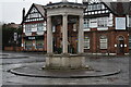
6
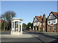
Mottingham War Memorial
This War Memorial in Mottingham now forms the centre of a mini-roundabout
Image: © Malc McDonald
Taken: 19 Mar 2011
0.15 miles
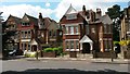
8
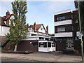
Mottingham Library
On Mottingham Road, near the West Park junction.
Image: © David Anstiss
Taken: 18 Sep 2011
0.15 miles
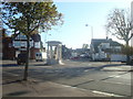
9
Mottingham War Memorial
Occupying the centre of the roundabout.
Image: © David Martin
Taken: 15 Feb 2022
0.16 miles
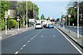
10
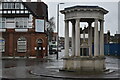
Mottingham War Memorial
With a view along Mottingham Road.
Image: © David Martin
Taken: 15 Feb 2022
0.16 miles