IMAGES TAKEN NEAR TO
Cornwallis Avenue, LONDON, SE9 3RF
Introduction
This page details the photographs taken nearby to Cornwallis Avenue, SE9 3RF by members of the Geograph project.
The Geograph project started in 2005 with the aim of publishing, organising and preserving representative images for every square kilometre of Great Britain, Ireland and the Isle of Man.

There are currently over 7.5m images from over14,400 individuals and you can help contribute to the project by visiting https://www.geograph.org.uk
Image Map
Images are licensed for reuse under creativecommons.org/licenses/by-sa/2.0
Notes
- Clicking on the map will re-center to the selected point.
- The higher the marker number, the further away the image location is from the centre of the postcode.
Image Listing (36 Images Found)
Images are licensed for reuse under creativecommons.org/licenses/by-sa/2.0
Image
Details
Distance
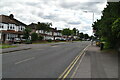
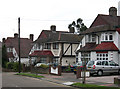
2
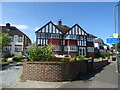
Semi-Detached Houses, New Eltham - Sidcup
Most of the housing in this quarter of the square was built in the mid-late 1930s, and most is semi-detached, often extended now from 3 to 4 bedrooms. The original very durable concrete (with pebble-chip) road surface remains, patched occasionally. The original grey 1930s heavy paving slabs have been relaid after cable TV installed their pipes and other equipment. The pink ones are post-war replacements for cracked slabs. Parking restrictions and yellow lines appeared in the 1990s.
Image: © Roger Kidd
Taken: 20 Jan 2005
0.07 miles
3
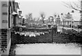
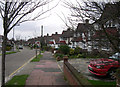
Front gardens in Telford Road, New Eltham
Telford Road was developed in the late 1930s with a mixture of chalet and standard types of semi-detached houses, all with these castellated brick walls dividing the front gardens from each other, and the pavement. The road had narrow grass verges planted with cherry blossom trees (pink).
The image has been scanned from a 35mm Ilford FP3 monochrome negative, date circa February or March 1964.
Image: © Roger D Kidd
Taken: 1 Feb 1964
0.07 miles
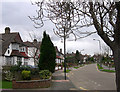
8
Semi-Detached Houses, New Eltham - Sidcup
The housing in this quarter of the square is almost exclusively semi-detached, built in the mid-late 1930s, with a lot of the chalet style buildings fashionable at the time. Some were sold in 1937 for £700 (2007 price un-extended, around £300,000) The road surface (apart from patches) is still the original hard concrete packed with tiny stones and pebbles. Many of these three bedroom semis have been extended.
Image: © Roger Kidd
Taken: 20 Jan 2005
0.11 miles
9
Semi-Detached Housing, New Eltham - Sidcup
This quarter of the square is almost exclusively made up of 1930s semi-detached housing, around half of it in the fashionable (at the time) chalet style with downstairs toilet and bathroom.
Since the 1970s many have been extended in a variety of ways. This image shows the original shape with original 1937 castellated front garden wall, and the next one which is now four bedroomed. The house by the telegraph pole still has the original 1937 castellated brick garden wall.
Image: © Roger Kidd
Taken: 20 Jan 2005
0.11 miles
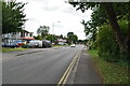
10
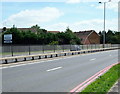
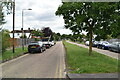
Sidcup By-Pass, New Eltham, SE9
With residential housing in Aldwick Close providing a backdrop, this is a view of the bypass (the A211) as it heads towards Sidcup (which it skirts on this suburb's southern side).
Image: © David Hallam-Jones
Taken: 17 Jun 2014
0.11 miles