IMAGES TAKEN NEAR TO
Bowmead, LONDON, SE9 3NL
Introduction
This page details the photographs taken nearby to Bowmead, SE9 3NL by members of the Geograph project.
The Geograph project started in 2005 with the aim of publishing, organising and preserving representative images for every square kilometre of Great Britain, Ireland and the Isle of Man.

There are currently over 7.5m images from over14,400 individuals and you can help contribute to the project by visiting https://www.geograph.org.uk
Image Map
Images are licensed for reuse under creativecommons.org/licenses/by-sa/2.0
Notes
- Clicking on the map will re-center to the selected point.
- The higher the marker number, the further away the image location is from the centre of the postcode.
Image Listing (26 Images Found)
Images are licensed for reuse under creativecommons.org/licenses/by-sa/2.0
Image
Details
Distance
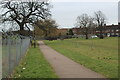
2
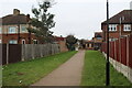
Path to Chapel Farm Road
Path between houses from open space Image
Image: © M J Roscoe
Taken: 11 Feb 2023
0.08 miles
4
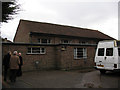
St Andrew's church hall
The hall is immediately behind the church Image
Image: © Stephen Craven
Taken: 14 Jan 2011
0.13 miles
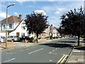
5
Green open space, Altash Way
Large area of parkland; there is a sports field to the right of the fence.
Image: © M J Roscoe
Taken: 11 Feb 2023
0.14 miles
6
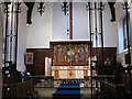
Chancel of St Andrew's church
The east end of the church interior - see Image for a view of the exterior.
Image: © Stephen Craven
Taken: 14 Jan 2011
0.14 miles
7
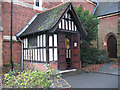
Porch of St Andrew's church
For a wider view of the church see Image This porch is on the north side of the church.
Image: © Stephen Craven
Taken: 14 Jan 2011
0.14 miles
8
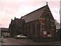
St Andrew's church, Mottingham
An Anglican church, built in 1871.
Image: © Stephen Craven
Taken: 14 Jan 2011
0.14 miles
10
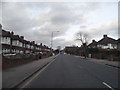
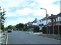
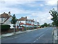
Court Road, Mottingham
This is a very good example of a ribbon development of anonymous semis along a main road which are found in most London suburbs.
Image: © David Howard
Taken: 23 Feb 2014
0.17 miles