IMAGES TAKEN NEAR TO
The Underwood, LONDON, SE9 3EN
Introduction
This page details the photographs taken nearby to The Underwood, SE9 3EN by members of the Geograph project.
The Geograph project started in 2005 with the aim of publishing, organising and preserving representative images for every square kilometre of Great Britain, Ireland and the Isle of Man.

There are currently over 7.5m images from over14,400 individuals and you can help contribute to the project by visiting https://www.geograph.org.uk
Image Map
Images are licensed for reuse under creativecommons.org/licenses/by-sa/2.0
Notes
- Clicking on the map will re-center to the selected point.
- The higher the marker number, the further away the image location is from the centre of the postcode.
Image Listing (12 Images Found)
Images are licensed for reuse under creativecommons.org/licenses/by-sa/2.0
Image
Details
Distance
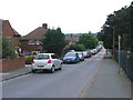
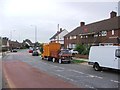
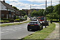
1
Northern end of The Underwood
A street corner row of three bungalows whose white facades caught my eye.
Image: © M J Roscoe
Taken: 11 Feb 2023
0.05 miles
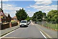
2
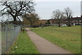
Green open space, Altash Way
Large area of parkland; there is a sports field to the right of the fence.
Image: © M J Roscoe
Taken: 11 Feb 2023
0.10 miles
3
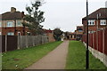
Path to Chapel Farm Road
Path between houses from open space Image
Image: © M J Roscoe
Taken: 11 Feb 2023
0.15 miles
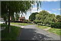
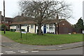
7
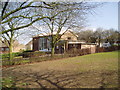
Coldharbour Community Hall, William Barefoot Drive, London SE 9
When the Coldharbour Estate was laid out by the then London County Council in the years following World War 2, everything was done to make it a pleasant place for those who would come to live there. And it is still a desirable location, with plenty of trees and open space, as can be seen here.
Image: © Dr Neil Clifton
Taken: 23 Mar 2006
0.22 miles