IMAGES TAKEN NEAR TO
Bromhedge, LONDON, SE9 3DZ
Introduction
This page details the photographs taken nearby to Bromhedge, SE9 3DZ by members of the Geograph project.
The Geograph project started in 2005 with the aim of publishing, organising and preserving representative images for every square kilometre of Great Britain, Ireland and the Isle of Man.

There are currently over 7.5m images from over14,400 individuals and you can help contribute to the project by visiting https://www.geograph.org.uk
Image Map
Images are licensed for reuse under creativecommons.org/licenses/by-sa/2.0
Notes
- Clicking on the map will re-center to the selected point.
- The higher the marker number, the further away the image location is from the centre of the postcode.
Image Listing (15 Images Found)
Images are licensed for reuse under creativecommons.org/licenses/by-sa/2.0
Image
Details
Distance
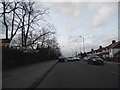
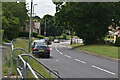
2
Mottingham Road, Mottingham
Another old-timer performing sterling service.
Image: © Ron Hann
Taken: Unknown
0.18 miles
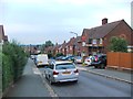
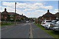
9
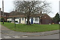
Northern end of The Underwood
A street corner row of three bungalows whose white facades caught my eye.
Image: © M J Roscoe
Taken: 11 Feb 2023
0.24 miles
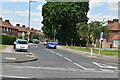
10
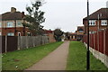
Path to Chapel Farm Road
Path between houses from open space Image
Image: © M J Roscoe
Taken: 11 Feb 2023
0.24 miles