IMAGES TAKEN NEAR TO
Sandling Rise, LONDON, SE9 3AT
Introduction
This page details the photographs taken nearby to Sandling Rise, SE9 3AT by members of the Geograph project.
The Geograph project started in 2005 with the aim of publishing, organising and preserving representative images for every square kilometre of Great Britain, Ireland and the Isle of Man.

There are currently over 7.5m images from over14,400 individuals and you can help contribute to the project by visiting https://www.geograph.org.uk
Image Map
Images are licensed for reuse under creativecommons.org/licenses/by-sa/2.0
Notes
- Clicking on the map will re-center to the selected point.
- The higher the marker number, the further away the image location is from the centre of the postcode.
Image Listing (51 Images Found)
Images are licensed for reuse under creativecommons.org/licenses/by-sa/2.0
Image
Details
Distance
2
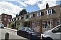
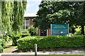
Mottingham, Coldharbour Library
On William Barefoot Drive, next to the police station: http://www.royalgreenwich.gov.uk/directory_record/1618/coldharbour_library
Image: © Mike Faherty
Taken: 27 May 2015
0.04 miles

5
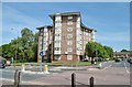
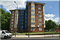
Mottingham, Coldharbour Crest
Apartment block on William Barefoot Drive.
Image: © Mike Faherty
Taken: 27 May 2015
0.07 miles
10
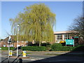
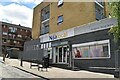
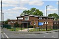
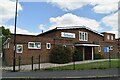
Coldharbour Community Hall
Community halls, like this one in South East London, can be used to host meetings and events for the local community.
Image: © Malc McDonald
Taken: 19 Mar 2011
0.09 miles