IMAGES TAKEN NEAR TO
Crossmead, LONDON, SE9 3AB
Introduction
This page details the photographs taken nearby to Crossmead, SE9 3AB by members of the Geograph project.
The Geograph project started in 2005 with the aim of publishing, organising and preserving representative images for every square kilometre of Great Britain, Ireland and the Isle of Man.

There are currently over 7.5m images from over14,400 individuals and you can help contribute to the project by visiting https://www.geograph.org.uk
Image Map
Images are licensed for reuse under creativecommons.org/licenses/by-sa/2.0
Notes
- Clicking on the map will re-center to the selected point.
- The higher the marker number, the further away the image location is from the centre of the postcode.
Image Listing (90 Images Found)
Images are licensed for reuse under creativecommons.org/licenses/by-sa/2.0
Image
Details
Distance
5
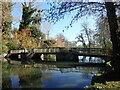
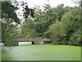
The Tarn in Eltham
The Tarn was originally a part of Eltham Palace’s gardens. The site was purchased in 1934 and became a public park. See https://www.fromthemurkydepths.co.uk/2019/07/13/hidden-treasures-the-tarn-in-eltham/
For the view from the bridge see https://www.geograph.org.uk/photo/6763363
Image: © Marathon
Taken: 26 Feb 2021
0.08 miles
6
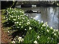
Daffodils at The Tarn
The Tarn was originally a part of Eltham Palace’s gardens. The site was purchased in 1934 and became a public park. See https://www.fromthemurkydepths.co.uk/2019/07/13/hidden-treasures-the-tarn-in-eltham/
Image: © Marathon
Taken: 19 Mar 2021
0.08 miles
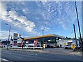
8
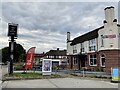
The Royal
Public House in Eltham, now closed.
Image: © Alan Hughes
Taken: 15 Aug 2021
0.09 miles
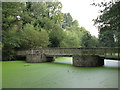
9
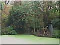
The Tarn, Mottingham (7)
See Image Looking towards the main channel into the lake; water also feeds into the lake from the Royal Blackheath Golf Course - see the map and satellite image http://openspace.nearby.org.uk/wheresthepath.htm?lat=51.44053334556385&lon=0.05610140794073635&gz=17&oz=10>=1.
Image: © Mike Quinn
Taken: 28 Sep 2010
0.09 miles