IMAGES TAKEN NEAR TO
Alderwood Road, LONDON, SE9 2LA
Introduction
This page details the photographs taken nearby to Alderwood Road, SE9 2LA by members of the Geograph project.
The Geograph project started in 2005 with the aim of publishing, organising and preserving representative images for every square kilometre of Great Britain, Ireland and the Isle of Man.

There are currently over 7.5m images from over14,400 individuals and you can help contribute to the project by visiting https://www.geograph.org.uk
Image Map
Images are licensed for reuse under creativecommons.org/licenses/by-sa/2.0
Notes
- Clicking on the map will re-center to the selected point.
- The higher the marker number, the further away the image location is from the centre of the postcode.
Image Listing (29 Images Found)
Images are licensed for reuse under creativecommons.org/licenses/by-sa/2.0
Image
Details
Distance
1
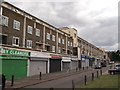
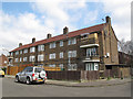
Shops on Bexley Road
Large block of flats, with a row of shops underneath.
Image: © David Anstiss
Taken: 15 Aug 2011
0.07 miles
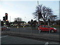
2
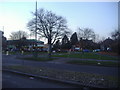
Junction of Bexley Road and Crown Woods Way
The BP garage was built in the last year or two before 2012
Image: © David Howard
Taken: 11 Mar 2012
0.11 miles
3
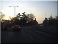
Junction of Blackfen Road and Avery Hill Road
Image: © David Howard
Taken: 11 Mar 2012
0.11 miles
4
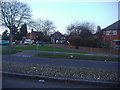
The junction of Bexley Road and Crown Woods Way
Image: © David Howard
Taken: 11 Mar 2012
0.11 miles
5
Housing on Anstridge Road
A three-storey housing block almost at the eastern extremity of Greenwich borough.
Image: © Stephen Craven
Taken: 6 Apr 2015
0.13 miles
6
Bexley Road at the junction of Crown Woods Way
Image: © David Howard
Taken: 23 Feb 2014
0.14 miles
7
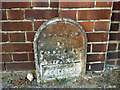
Borough of Woolwich boundary marker
Dated 1903, this marked the outer limit of the Metropolitan Borough of Woolwich, and so the boundary between the counties of London and Kent. With the creation of Greater London, this became the boundary between the London Boroughs of Greenwich and Bexley, Woolwich being absorbed into Greenwich. At this point the A210 changes name - Bexley Road in Greenwich, Blackfen Road in Bexley. South of the A210 here is a road named Parish Gate Drive, with the boundary initially running down its western side.
Image: © Robin Webster
Taken: 26 Feb 2012
0.15 miles
8
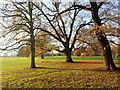
Avery Hill Park
Avery Hill Park was once the grounds of the mansion built in 1890 by the Victorian entrepreneur John Thomas North who made his fortune by exporting fertiliser from Chile. The mansion is now part of Greenwich University. The park includes the famous Winter Garden. The London County Council acquired the site in July 1902.
Image: © Marathon
Taken: 11 Dec 2020
0.15 miles
9
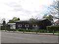
Anstridge Community Hall
A function room on Anstridge Road, Eltham, since 1993 it has been one of five managed by the St Mary's Community Complex http://stmarys-eltham.co.uk/
Image: © Stephen Craven
Taken: 6 Apr 2015
0.16 miles
10
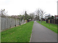
Path between Avery Hill Road and Anstridge Road
The path forms part of the Shuttle Riverway.
Image: © Stephen Craven
Taken: 6 Apr 2015
0.16 miles