IMAGES TAKEN NEAR TO
Lannoy Road, LONDON, SE9 2BN
Introduction
This page details the photographs taken nearby to Lannoy Road, SE9 2BN by members of the Geograph project.
The Geograph project started in 2005 with the aim of publishing, organising and preserving representative images for every square kilometre of Great Britain, Ireland and the Isle of Man.

There are currently over 7.5m images from over14,400 individuals and you can help contribute to the project by visiting https://www.geograph.org.uk
Image Map
Images are licensed for reuse under creativecommons.org/licenses/by-sa/2.0
Notes
- Clicking on the map will re-center to the selected point.
- The higher the marker number, the further away the image location is from the centre of the postcode.
Image Listing (94 Images Found)
Images are licensed for reuse under creativecommons.org/licenses/by-sa/2.0
Image
Details
Distance
2
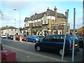
The Beehive Pub, New Eltham, London SE9
Image: © Stacey Harris
Taken: 15 Nov 2008
0.07 miles
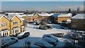
4
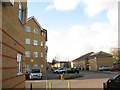
Stanley Close, New Eltham
This new (post 2000) development is named after the Stanley tool factory that formerly occupied the site http://www.mathsinstruments.me.uk/page43.html
Image: © Stephen Craven
Taken: 25 Oct 2009
0.08 miles
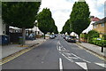
6
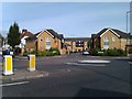
View across roundabout into Stanley Close
Image: © David Martin
Taken: 20 Sep 2012
0.08 miles
7
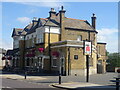
The Beehive, New Eltham
On Footscray Road (A211).
See Image] for sign.
Image: © JThomas
Taken: 24 Jun 2022
0.09 miles
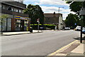
9
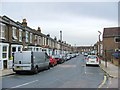
Footscray Road, New Eltham, London SE9
Image: © Stacey Harris
Taken: 15 Nov 2008
0.09 miles