IMAGES TAKEN NEAR TO
Berryhill, LONDON, SE9 1QP
Introduction
This page details the photographs taken nearby to Berryhill, SE9 1QP by members of the Geograph project.
The Geograph project started in 2005 with the aim of publishing, organising and preserving representative images for every square kilometre of Great Britain, Ireland and the Isle of Man.

There are currently over 7.5m images from over14,400 individuals and you can help contribute to the project by visiting https://www.geograph.org.uk
Image Map
Images are licensed for reuse under creativecommons.org/licenses/by-sa/2.0
Notes
- Clicking on the map will re-center to the selected point.
- The higher the marker number, the further away the image location is from the centre of the postcode.
Image Listing (42 Images Found)
Images are licensed for reuse under creativecommons.org/licenses/by-sa/2.0
Image
Details
Distance
1
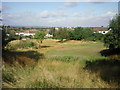
Eltham Park North
The park known as Eltham Park North (Eltham Park South is the other side of the railway and the A2) contains the extensive Shepherdleas Wood. This view looks across Eltham towards London with the end of the ridge on the left skyline taking in Forest Hill, One Tree Hill and Nunhead Cemetery from left to right.
Image: © Marathon
Taken: 16 Jul 2010
0.04 miles
2
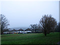
Western end of Eltham Park North
Much of this side of the park is wooded, but with a small area of open land at the western end. One should be able to see the top of Shooters Hill in this view but it was covered in low cloud.
Image: © Stephen Craven
Taken: 4 Jan 2015
0.06 miles
3
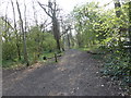
The Capital Ring (017)
This picture is definitely on the Capital Ring but I can't place it with accuracy.
Image: © Shazz
Taken: 29 Mar 2019
0.07 miles
4
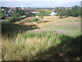
View from Eltham Park North
This view looks past the back gardens of the houses in Eltham Park Gardens to the Sydenham Hill/Forest Hill/Honor Oak ridge on the horizon.
Image: © Marathon
Taken: 16 Jul 2010
0.09 miles
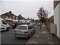
6
Dumbreck Road at the junction of Glenesk Road
Image: © David Howard
Taken: 30 Aug 2015
0.11 miles
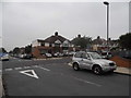
7

Eltham Park Gardens
The name is that of a road. This area of Eltham was built up in the interwar years in planned fashion, as can be seen from the grid pattern of roads, but came to a halt at Eltham Park.
Image: © Stephen Craven
Taken: 4 Jan 2015
0.13 miles
8

The staffyard, Eltham Park North
The staffyard (park maintenance depot) at the western end of the park, closed as it was Sunday.
Image: © Stephen Craven
Taken: 4 Jan 2015
0.13 miles
9
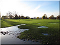
Waterlogged ground
Looking away from the Long Pond in Eltham Park North.
Image: © Stephen Craven
Taken: 18 Nov 2012
0.14 miles
10
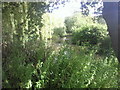
The Long Pond at Eltham Park North
This view takes in the whole length of the Long Pond. As can be seen, it is surrounded by fairly dense vegetation.
Image: © Marathon
Taken: 16 Jul 2010
0.14 miles