IMAGES TAKEN NEAR TO
Westmount Road, LONDON, SE9 1NB
Introduction
This page details the photographs taken nearby to Westmount Road, SE9 1NB by members of the Geograph project.
The Geograph project started in 2005 with the aim of publishing, organising and preserving representative images for every square kilometre of Great Britain, Ireland and the Isle of Man.

There are currently over 7.5m images from over14,400 individuals and you can help contribute to the project by visiting https://www.geograph.org.uk
Image Map (Loading...)


Getting Data...Please wait
Leaflet Map data © OpenStreetMap
Images are licensed for reuse under creativecommons.org/licenses/by-sa/2.0
Notes
- Clicking on the map will re-center to the selected point.
- The higher the marker number, the further away the image location is from the centre of the postcode.
Image Listing (65 Images Found)
Images are licensed for reuse under creativecommons.org/licenses/by-sa/2.0
Image
Details
Distance
1
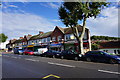
Row of shops on Well Hall Road
You can see a bit of Shooters Hill behind on the right.
Image: © Bill Boaden
Taken: 11 Oct 2014
0.04 miles
3
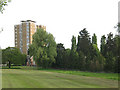
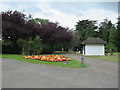
Open space off Broad Walk
This apparently unnamed triangular open space occupies about 1.5ha on the corner of Well Hall Road and Broad Walk. The tower block in the background is on Well Hall Road.
Image: © Stephen Craven
Taken: 9 May 2009
0.08 miles
4
Greenwich Cemetery
Greenwich Cemetery was founded in 1856 by Greenwich Burial Board on a hilly site, with an entrance in Well Hall Road. At the top of the hill are the Commonwealth War Graves and the Heroes Corner and War Memorial. The panoramic views are the finest from any cemetery in London and are some of the best anywhere in London. This view is looking from within the cemetery towards the entrance.
Image: © Marathon
Taken: 26 Aug 2022
0.08 miles
5
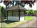
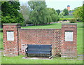
Greenwich Cemetery, London SE9
One of half a dozen weather-protection shelters in this cemetery. The majority of these are boarded up as an anti-social behaviour strategy. This one is situated near to the entrance on Well Hall Road, the latter identifiable by its 1930s (?) brick piers with stone capitals. The cemetery covers 9.5 hectares (i.e. approximately 24 acres) and is sandwiched between Mayday Gardens and Dunblane Road, Eltham.
Image: © David Hallam-Jones
Taken: 3 May 2014
0.08 miles
6
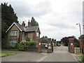
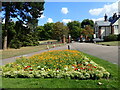
Greenwich Cemetery, near Eltham
Gates at the entrance to Greenwich Cemetery, near Eltham. To the left of the image is the cemetery superintendent's cottage.
Image: © Malc McDonald
Taken: 14 Jul 2019
0.09 miles
7
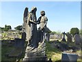
The grave of a young girl in Greenwich Cemetery
Greenwich Cemetery was founded in 1856 by Greenwich Burial Board on a hilly site, with an entrance in Well Hall Road. At the top of the hill are the Commonwealth War Graves and the Heroes Corner and War Memorial. The panoramic views are the finest from any cemetery in London and are some of the best anywhere in London. This is near the entrance. It is to Olive Vera Kemp who died on 16th September 1938 aged 13 years and 3 months.
For more about Greenwich Cemetery see https://londongardenstrust.org/inventory/gardens-online-record.php?ID=GRN026
Image: © Marathon
Taken: 27 May 2020
0.10 miles
8
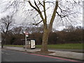
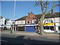
Bus stop on Well Hall Road by Eltham Common
Image: © David Howard
Taken: 23 Feb 2014
0.10 miles
9
Greenwich Cemetery, near Eltham
Greenwich Cemetery, near Eltham in south east London.
Image: © Malc McDonald
Taken: 14 Jul 2019
0.10 miles
10
Well Hall Road, London SE9
This particular "King George's Field" is an irregular shaped piece of common land situated between Well Hall Road (i.e. the A205) and a minor road known as Broad Walk. It is opposite Eltham Common and is therefore also known as Little Eltham Common. After King George V's death in 1939 the Lord Mayor of London formed a committee to decide upon a memorial that would not be solely based upon the idea of a statue. As a result, later in the same year, it was decided to erect a single statue in London but also to set up the King George's Fields Foundation to promote and assist in the establishment of a series of playing fields throughout the United Kingdom. Each of the playing fields was to be styled a "King George's Field" and was to be distinguished by heraldic panels or other appropriate tablet medallion or inscription commemorating the King and of a design approved by the Administrative Council. After its purchase the land was to pass to the National Playing Fields Association who would "preserve and safeguard the land for the public benefit". Land was still being acquired for the purpose during the 1950s and early 1960s and when the King George's Fields Foundation was dissolved in 1965 there were 471 King George Playing Fields in the UK. This one consists of 1.99 hectares or 4.92 acres and is now managed by the London Borough of Greenwich. A former water tower on the site of the former Brook Hospital, Shooters Hill (opposite Baker Road) is visible in the distance.
Image: © David Hallam-Jones
Taken: 3 May 2014
0.11 miles