IMAGES TAKEN NEAR TO
Brome Road, LONDON, SE9 1LE
Introduction
This page details the photographs taken nearby to Brome Road, SE9 1LE by members of the Geograph project.
The Geograph project started in 2005 with the aim of publishing, organising and preserving representative images for every square kilometre of Great Britain, Ireland and the Isle of Man.

There are currently over 7.5m images from over14,400 individuals and you can help contribute to the project by visiting https://www.geograph.org.uk
Image Map
Images are licensed for reuse under creativecommons.org/licenses/by-sa/2.0
Notes
- Clicking on the map will re-center to the selected point.
- The higher the marker number, the further away the image location is from the centre of the postcode.
Image Listing (47 Images Found)
Images are licensed for reuse under creativecommons.org/licenses/by-sa/2.0
Image
Details
Distance
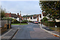

4
Grangehill Road, Eltham
Residential road running north from Rochester Way
Image: © Chris Heaton
Taken: 23 Oct 2016
0.11 miles


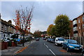
9
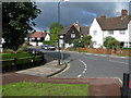
Downman Road, SE9
Viewed from Well Hall Road.
Image: © Danny P Robinson
Taken: 28 Aug 2006
0.15 miles
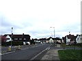
10
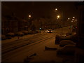
Westmount Rd, Jct Rochester Way
The 1st snowfall in 2007.
Image: © Dino
Taken: 28 Feb 2004
0.16 miles