IMAGES TAKEN NEAR TO
Shrapnel Road, LONDON, SE9 1LB
Introduction
This page details the photographs taken nearby to Shrapnel Road, SE9 1LB by members of the Geograph project.
The Geograph project started in 2005 with the aim of publishing, organising and preserving representative images for every square kilometre of Great Britain, Ireland and the Isle of Man.

There are currently over 7.5m images from over14,400 individuals and you can help contribute to the project by visiting https://www.geograph.org.uk
Image Map
Images are licensed for reuse under creativecommons.org/licenses/by-sa/2.0
Notes
- Clicking on the map will re-center to the selected point.
- The higher the marker number, the further away the image location is from the centre of the postcode.
Image Listing (52 Images Found)
Images are licensed for reuse under creativecommons.org/licenses/by-sa/2.0
Image
Details
Distance
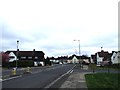


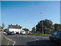
6
Downman Road, SE9
Viewed from Well Hall Road.
Image: © Danny P Robinson
Taken: 28 Aug 2006
0.12 miles
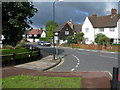
8
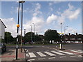
Well Hall Roundabout
Rochester Way (from Eltham Park) reaches the roundabout on the A205 South Circular.
Image: © David Anstiss
Taken: 11 Sep 2011
0.13 miles
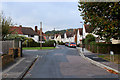
9
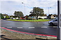
Roundabout on the South Circular Road
This is mainly the junction between the A205 and the A208, though other minor roads also join the roundabout.
Image: © Bill Boaden
Taken: 11 Oct 2014
0.14 miles
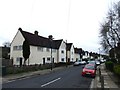
10
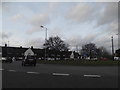
Roundabout on the South Circular Road, Eltham
Joining Well Hall Road from the south
Image: © David Howard
Taken: 23 Feb 2014
0.14 miles