IMAGES TAKEN NEAR TO
Balcaskie Road, LONDON, SE9 1HQ
Introduction
This page details the photographs taken nearby to Balcaskie Road, SE9 1HQ by members of the Geograph project.
The Geograph project started in 2005 with the aim of publishing, organising and preserving representative images for every square kilometre of Great Britain, Ireland and the Isle of Man.

There are currently over 7.5m images from over14,400 individuals and you can help contribute to the project by visiting https://www.geograph.org.uk
Image Map
Images are licensed for reuse under creativecommons.org/licenses/by-sa/2.0
Notes
- Clicking on the map will re-center to the selected point.
- The higher the marker number, the further away the image location is from the centre of the postcode.
Image Listing (73 Images Found)
Images are licensed for reuse under creativecommons.org/licenses/by-sa/2.0
Image
Details
Distance
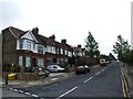
1

Balcaskie Road, Eltham
Terraces of four houses. Taken a few yards from the junction with Glenlea Road.
Image: © Derek Harper
Taken: 20 May 2006
0.04 miles


5

Glenlea Path, Eltham, SE London
This path joins Glenlea Road 20 metres behind the photographer and this is the view towards Well Hall Road, i.e. the A280. This raised footpath runs parallel with Eltham Bus Station with the bus station being situated on the other side of the waist-high concrete wall but at a much lower lever. The traffic signals ahead mark the bus station's entrance/ exit. It is perhaps safe to assume that this path was constructed at the same time as the bus station was being built (mid-1980s), to avoid pedestrians and cyclists having to compete with bus station traffic?
Image: © David Hallam-Jones
Taken: 20 Mar 2016
0.11 miles
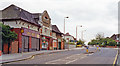
7

A2 at Eltham
The dual carriageway heads beneath the Eltham railway and bus stations interchange. A view after it has emerged is at Image
Image: © Derek Harper
Taken: 20 May 2006
0.12 miles
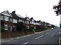
8
Westcombe Road, Eltham at entrance of former Eltham Park station, 1991
View southward, with Hither Green and London (Charing Cross/Cannon Street) to the right: ex-SE&CR London - Dartford Loop Line. Together with Eltham Well Hall station, Eltham Park station was closed 17/3/85 and replaced by the new station at Eltham on Well Hall Road.
Image: © Ben Brooksbank
Taken: 18 Aug 1991
0.14 miles
9

Dunvegan Path & Eltham Station, SE London
Dunvegan Path connects Dunvegan Road - behind the railings seen here - to the Eltham railway station's car parking facilities. As perhaps can be discerned, the path is routed beneath the railway tracks? Eltham Bus Station (3-4 minutes ahead) can also be reached via this route.
Image: © David Hallam-Jones
Taken: 20 Mar 2016
0.14 miles
10
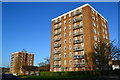
Blocks of flats in Strongbow Crescent
Image: © David Martin
Taken: 19 Jan 2020
0.15 miles