IMAGES TAKEN NEAR TO
Granby Road, LONDON, SE9 1EH
Introduction
This page details the photographs taken nearby to Granby Road, SE9 1EH by members of the Geograph project.
The Geograph project started in 2005 with the aim of publishing, organising and preserving representative images for every square kilometre of Great Britain, Ireland and the Isle of Man.

There are currently over 7.5m images from over14,400 individuals and you can help contribute to the project by visiting https://www.geograph.org.uk
Image Map
Images are licensed for reuse under creativecommons.org/licenses/by-sa/2.0
Notes
- Clicking on the map will re-center to the selected point.
- The higher the marker number, the further away the image location is from the centre of the postcode.
Image Listing (65 Images Found)
Images are licensed for reuse under creativecommons.org/licenses/by-sa/2.0
Image
Details
Distance
1
Steps down to Castlewood Drive, Eltham
The steps are the access to/from the woodland on Eltham Common at its western end. The road at the foot of the steps is Castlewood Drive, and beyond and below it, Heatherbank.
Image: © Stephen Craven
Taken: 9 May 2009
0.11 miles
3
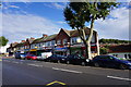
Row of shops on Well Hall Road
You can see a bit of Shooters Hill behind on the right.
Image: © Bill Boaden
Taken: 11 Oct 2014
0.15 miles
5
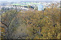
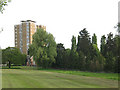
View west from Severndroog Castle
Looking over south east London from viewing platform on top of the castle; Castlewood is in the foreground. The tall blue building faces Well Hall Road.
Image: © M J Roscoe
Taken: 10 Nov 2017
0.16 miles
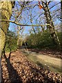
6
Branches and shadows
A pattern of branches and shadows in woodland near Eltham.
Image: © Alan Hughes
Taken: 19 Jan 2020
0.16 miles
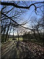
7
Woodland path and fallen trees
Path through Castle Wood, Eltham.
Image: © Alan Hughes
Taken: 19 Jan 2020
0.17 miles
8
Castle Woods Vicinity, Eltham Park, SE London
The southern edge of Castle Woods, part of the Shooters Hill Woodlands, is to be found 20 metres behind the photographer. Parts of these ancient woodlands are considered to be at least 8,000 years old and trees from them were used in the Woolwich and Deptford dockyards for shipbuilding in the past. An access/exit point to and from this 'green space' is to be found ahead, between Nos. 35-37, Crookston Road. The houses ahead are situated in the northern part of the 'Eltham Park' area.
Image: © David Hallam-Jones
Taken: 20 Mar 2016
0.18 miles
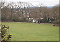
9
Open space off Broad Walk
This apparently unnamed triangular open space occupies about 1.5ha on the corner of Well Hall Road and Broad Walk. The tower block in the background is on Well Hall Road.
Image: © Stephen Craven
Taken: 9 May 2009
0.21 miles
10
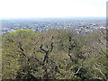
View from Severndroog Castle
Severndroog Castle is near the top of Shooters Hill and at 432 feet above sea level there are wonderful views from the top where it is said seven counties can be seen on a clear day. This day was slightly misty and the furthest that could be seen was the Wembley Arch.
The main London to Dover road went over Shooters Hill and was plagued by highwaymen. The name was first recorded in 1226 as 'the hill of the shooter or archer'.
Severndroog Castle was built to commemorate Commodore Sir William James who, in April 1755, attacked and destroyed the island fortress of Suvarnadurg (in English: Severndroog) on the western coast of India, between Mumbai and Goa. James died in 1783 and the castle was built as a memorial to him by his widow, Lady James of Eltham.The first stone was laid on 2nd April 1784.
Development of the area began in the 18th century and large houses were built for rich owners who wanted to live in the country but be near London. By the 20th century houses covered much of the farmland at the foot of Shooters Hill. Between 1922 and 1934 the London County Council bought large parts of the woodland as open space for the community.
Severndroog Castle itself was derelict for many years but has now been fully restored, following a large Heritage Lottery Fund grant, and is open to the public - see http://www.severndroogcastle.org.uk/visitor-info.html and http://www.severndroogcastle.org.uk/learning-centre.html
Image: © Marathon
Taken: 9 Apr 2017
0.21 miles