IMAGES TAKEN NEAR TO
Strongbow Crescent, LONDON, SE9 1DN
Introduction
This page details the photographs taken nearby to Strongbow Crescent, SE9 1DN by members of the Geograph project.
The Geograph project started in 2005 with the aim of publishing, organising and preserving representative images for every square kilometre of Great Britain, Ireland and the Isle of Man.

There are currently over 7.5m images from over14,400 individuals and you can help contribute to the project by visiting https://www.geograph.org.uk
Image Map
Images are licensed for reuse under creativecommons.org/licenses/by-sa/2.0
Notes
- Clicking on the map will re-center to the selected point.
- The higher the marker number, the further away the image location is from the centre of the postcode.
Image Listing (149 Images Found)
Images are licensed for reuse under creativecommons.org/licenses/by-sa/2.0
Image
Details
Distance
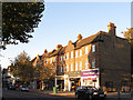
3
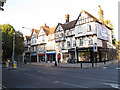
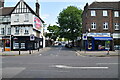
Eltham shops (3) - Sherard Mansions
Eltham has a good range of shops, but they are strung out along the main roads leading away from the parish church, rather than there being one "shopping centre". The nearest one here, on the corner of Well Hall Road and Dobell Road, was as of 2011 an estate agent. Beyond are a hairdressers, new-age spirituality shop, and a couple of vacant units.
The block as a whole is called "Sherard Mansions" according to the name above the door in the centre of the parade. A woman is going in, presumably to access one of the flats above the shops. The mock half-timbered style is very "1930s", the period when Eltham expanded rapidly.
Image: © Stephen Craven
Taken: 15 Oct 2011
0.06 miles
7
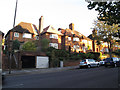
Houses on Well Hall Road
The houses shown here are large, brick ones reached by long flights of steps. The garages in the foreground look like a later addition.
Image: © Stephen Craven
Taken: 15 Oct 2011
0.07 miles
9
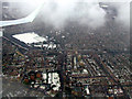
Eltham from the air
The snow covered area below the wing is the University of Greenwich Athletic Ground. Eltham railway station is dead centre of the photo which was taken from a London City bound flight from Glasgow.
Image: © Thomas Nugent
Taken: 6 Feb 2012
0.09 miles
10
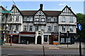
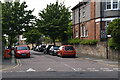
Eltham shops (4)
Eltham has a good range of shops, but they are strung out along the main roads leading away from the parish church, rather than there being one "shopping centre". This set just north of the police station included, as of 2011, an estate agent, hairdressers and bridal wear shop (I could not identify the others behind the trees).
Image: © Stephen Craven
Taken: 15 Oct 2011
0.09 miles