IMAGES TAKEN NEAR TO
Eltham Park Gardens, LONDON, SE9 1AP
Introduction
This page details the photographs taken nearby to Eltham Park Gardens, SE9 1AP by members of the Geograph project.
The Geograph project started in 2005 with the aim of publishing, organising and preserving representative images for every square kilometre of Great Britain, Ireland and the Isle of Man.

There are currently over 7.5m images from over14,400 individuals and you can help contribute to the project by visiting https://www.geograph.org.uk
Image Map
Images are licensed for reuse under creativecommons.org/licenses/by-sa/2.0
Notes
- Clicking on the map will re-center to the selected point.
- The higher the marker number, the further away the image location is from the centre of the postcode.
Image Listing (59 Images Found)
Images are licensed for reuse under creativecommons.org/licenses/by-sa/2.0
Image
Details
Distance
1
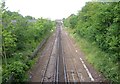
Bexleyheath Line , Eltham
Seen from Glenesk Road, from the second of the two bridges shown in Image, looking towards the Wesrmount Road bridge.
Image: © Derek Harper
Taken: 20 May 2006
0.05 miles
2
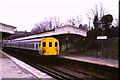
Eltham Park station
Eltham Park station was a suburban station in South East London. It closed in 1985, replaced by a new station at Eltham a short distance further west. Eltham Well Hall station closed at the same time.
The reason for replacing the stations was to release land to allow the Rochester Way Relief Road, part of the trunk A2 road, to be built.
This image was taken on the last day before Eltham Park station closed. A more recent image of the remains of the station is here:Image More information about the station is on the Disused Stations website: http://www.disused-stations.org.uk/e/eltham_park/index.shtml
Image: © Malc McDonald
Taken: 16 Mar 1985
0.09 miles
4
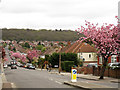
Glenesk Road, Eltham
A long straight suburban road, seen here with the cherry trees in blossom. In the distance is Jack Wood.
Image: © Stephen Craven
Taken: 4 May 2013
0.10 miles
5
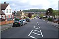
Glenesk Road, Eltham
A suburban road that runs straight for well over a kilometre. Here it crosses Eltham Park Gardens, heading towards Jackwood. Seen from the north side of the bridge over the Bexleyheath railway line.
Image: © Derek Harper
Taken: 20 May 2006
0.10 miles
6
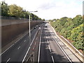
A2 to Kidbrooke
As seen from Image
This dual carriageway leads from Kent towards central London, via Blackheath. This is the Rochester Relief Road heading towards Shooters Hill.
Elham Park North is on the right.
Image: © David Anstiss
Taken: 11 Sep 2011
0.10 miles
7
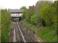
Platforms of the former Eltham Park station
Looking west from Glenesk Road, the platforms of this closed station are still visible nearly 30 years later. Another contributor was there on the last day of operation: Image The station buildings are also present but derelict Image
Image: © Stephen Craven
Taken: 4 May 2013
0.11 miles