IMAGES TAKEN NEAR TO
Abinger Grove, LONDON, SE8 5UW
Introduction
This page details the photographs taken nearby to Abinger Grove, SE8 5UW by members of the Geograph project.
The Geograph project started in 2005 with the aim of publishing, organising and preserving representative images for every square kilometre of Great Britain, Ireland and the Isle of Man.

There are currently over 7.5m images from over14,400 individuals and you can help contribute to the project by visiting https://www.geograph.org.uk
Image Map
Images are licensed for reuse under creativecommons.org/licenses/by-sa/2.0
Notes
- Clicking on the map will re-center to the selected point.
- The higher the marker number, the further away the image location is from the centre of the postcode.
Image Listing (154 Images Found)
Images are licensed for reuse under creativecommons.org/licenses/by-sa/2.0
Image
Details
Distance
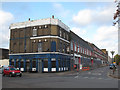
1
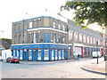
The Lord Palmerston, Deptford
Another pub named after a Victorian peer (see Image only a few hundred metres away). Palmerston was Prime Minister from 1855-1865, dying in office at the age of 80.
Image: © Stephen Craven
Taken: 17 Jun 2008
0.02 miles
2
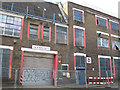
Childers Street warehouses: Goods Out
A traditional label for a warehouse door, which might well disappear in the refurbishment. For context, see Image
Image: © Stephen Craven
Taken: 27 Oct 2014
0.02 miles
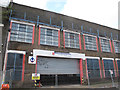
3
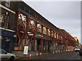
Demolition of the SR building
Demolition contractors started working on the stripping out of the factory building Image in December 2014, and by the first week of 2015 the roof was coming off. It was still not clear whether the final result would be a complete demolition of the building, or retention of the facade as part of a complete internal rebuilding. But either way it was clearly going to be more than the advertised "refurbishment".
Image: © Stephen Craven
Taken: 7 Jan 2015
0.03 miles
5
Childers Street warehouses
This warehouse building had been cleared out and fenced off in recent weeks. I took some photos in case it was about to be demolished although one worker told me it was only being "refurbished". This is the view from the Arklow Road end. The Lord Palmerston pub on the corner had been closed for some time. For a view from the other (Rolt Street) end see Image
Image: © Stephen Craven
Taken: 27 Oct 2014
0.03 miles
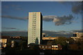
6
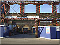
A glimpse of the viaduct
The old SR building on Childers Street Image was by this time almost completely demolished, apart from the facade that was being retained. Through the contractor's entrance can be seen a few arches of the London-Greenwich railway viaduct that had been hidden from view for a long time.
Image: © Stephen Craven
Taken: 1 Apr 2015
0.03 miles
7
Childers Street warehouses: MTMI
The easternmost goods entrance, most recently used by the Mountain Top Ministries International church. For context, see Image
Image: © Stephen Craven
Taken: 27 Oct 2014
0.03 miles
8
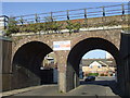
Viaduct over Arklow Road
Unusually, this road is spanned by two standard width arches of the London-Greenwich rail viaduct rather than one wide one, suggesting that the railway was there before the road.
Image: © Stephen Craven
Taken: 17 Jun 2008
0.04 miles
9

Factories on Childers Street, Deptford
In an area with rapid redevelopment of industrial sites for housing, this is one of the few remaining streets with industrial use (as of 2009, Douglas's cardboard box factory at the near end on the corner of Rolt Street, and SR Communications at the far end).
Image: © Stephen Craven
Taken: 18 Jul 2009
0.04 miles
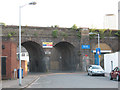
10
Railway bridge, Arklow Road, Deptford
This two-arched bridge carries the London to Greenwich railway line across Arklow Road, in Deptford.
Image: © Malc McDonald
Taken: 22 Oct 2011
0.05 miles