IMAGES TAKEN NEAR TO
Evelyn Street, LONDON, SE8 5RQ
Introduction
This page details the photographs taken nearby to Evelyn Street, SE8 5RQ by members of the Geograph project.
The Geograph project started in 2005 with the aim of publishing, organising and preserving representative images for every square kilometre of Great Britain, Ireland and the Isle of Man.

There are currently over 7.5m images from over14,400 individuals and you can help contribute to the project by visiting https://www.geograph.org.uk
Image Map
Images are licensed for reuse under creativecommons.org/licenses/by-sa/2.0
Notes
- Clicking on the map will re-center to the selected point.
- The higher the marker number, the further away the image location is from the centre of the postcode.
Image Listing (106 Images Found)
Images are licensed for reuse under creativecommons.org/licenses/by-sa/2.0
Image
Details
Distance
1
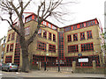
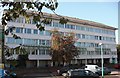
Marathon Science School, Deptford
A boys' secondary school on the corner of Evelyn Street and Croft Street.
Image: © Stephen Craven
Taken: 19 Apr 2014
0.01 miles
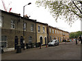
2
Houses on Croft Street, Deptford
The flat-topped entrance to the car park behind, with accommodation above, is an unusual detail in a modern building.
Image: © Stephen Craven
Taken: 19 Apr 2014
0.02 miles
3
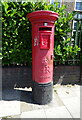
George V postbox on Evelyn Street
Postbox No. SE8 12.
Image: © JThomas
Taken: 20 Jun 2022
0.03 miles
4
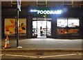
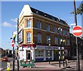
Foodmart on Lower Road, Bermondsey
It was Cost Less Express a year ago
Image: © David Howard
Taken: 12 Aug 2017
0.04 miles
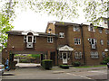
5
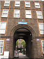
Entrance to Pomona House
The grand archway into the LCC (London County Council) Deptford Park housing estate, built 1950. Source: http://ukhousing.wikia.com/wiki/Deptford_Park_Estate
Image: © Stephen Craven
Taken: 19 Apr 2014
0.05 miles
6
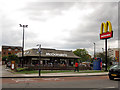
McDonald's, Deptford
A busy fast-food restaurant on the main road (Evelyn Street), with drive-thru facility.
Image: © Stephen Craven
Taken: 19 Apr 2014
0.05 miles
7
Merry Cricketers pub (site of). 276, Lower Road, Rotherhithe, London, SE16
At the junction with Bestwood Street (left) and first recorded in 1870. Believed that it ceased trading in the early 1990's. Externally unchanged from 1960.
Image: © Chris Lordan
Taken: 12 Oct 2009
0.05 miles
8
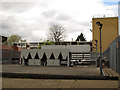
Industrial plant, Croft Street, Deptford
I have not been able to find out which business this plant belongs to or what it is for.
Image: © Stephen Craven
Taken: 19 Apr 2014
0.08 miles
9
Osprey Estate (part) Lower Road, Rotherhithe, London, SE16
The estate consists of seven buildings named :- Dunlin House (shown), Egret House, Fulmar House, Raven House, Sheldrake House, Siskin House and Tawney Way. The last is long and overlooks Lower Road. Built in the 1970's upon Maynard Road, Osprey Street, Trident Street and William Street. In 1868 Trident Street was named Wellington Street but changed before 1894.
Image: © Chris Lordan
Taken: 12 Oct 2009
0.08 miles
10
Croft Street, Deptford
A contrast between the older housing on Croft Street and the newer development of Woodcroft Mews behind security gates.
Image: © Stephen Craven
Taken: 19 Apr 2014
0.09 miles