IMAGES TAKEN NEAR TO
Trundleys Road, LONDON, SE8 5JX
Introduction
This page details the photographs taken nearby to Trundleys Road, SE8 5JX by members of the Geograph project.
The Geograph project started in 2005 with the aim of publishing, organising and preserving representative images for every square kilometre of Great Britain, Ireland and the Isle of Man.

There are currently over 7.5m images from over14,400 individuals and you can help contribute to the project by visiting https://www.geograph.org.uk
Image Map
Images are licensed for reuse under creativecommons.org/licenses/by-sa/2.0
Notes
- Clicking on the map will re-center to the selected point.
- The higher the marker number, the further away the image location is from the centre of the postcode.
Image Listing (180 Images Found)
Images are licensed for reuse under creativecommons.org/licenses/by-sa/2.0
Image
Details
Distance
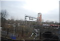
1
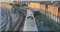
View from a Train
The railway is up high on viaducts and embankments all along here, with occasional views in between blocks of building.
The squirly monochrome graffiti along here improves the picture, I think.
Image: © Des Blenkinsopp
Taken: 2 Dec 2019
0.05 miles
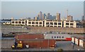
2
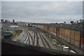
Silwood Triangle sidings in construction
A set of sidings for London Overground trains being installed, to supplement the nearby depot Image Although I could have got physically closer, the security guard politely asked me not to go beyond this point.
Image: © Stephen Craven
Taken: 25 Jan 2014
0.06 miles
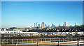
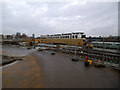
5
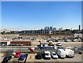
Big Building Site
This large plot inside a railway triangle is under redevelopment.
A train window shot, so apologies for slight blur.
The famous Docklands skyline is in the background.
Image: © Des Blenkinsopp
Taken: 3 Jul 2014
0.09 miles
6
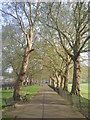
Avenue of plane trees in Deptford Park
The site of Deptford Park was originally a market garden. It was sold by the Evelyn family to the London County Council, in 1884, and the park was officially opened to the public on 7th June 1897. This fine avenue of plane trees runs along the western side of the park, parallel to Scawen Road.
Image: © Marathon
Taken: 19 Apr 2011
0.09 miles
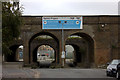
8

Viaducts on Landmann Way
There are actually three railway viaducts over the road here. The nearest, with a Southeastern train crossing it, is the line to Lewisham. The furthest is the Greenwich line. In between is a defunct viaduct that used to carry the lines from the disused Bricklayers Arms goods yard.
The road has been lowered beneath the viaducts, and hefty concrete kerbs installed to protect the viaduct piers, because of the car transporters taking recovered vehicles to the car pound beyond.
Image: © Stephen Craven
Taken: 23 Aug 2010
0.10 miles