IMAGES TAKEN NEAR TO
Chilton Grove, LONDON, SE8 5EG
Introduction
This page details the photographs taken nearby to Chilton Grove, SE8 5EG by members of the Geograph project.
The Geograph project started in 2005 with the aim of publishing, organising and preserving representative images for every square kilometre of Great Britain, Ireland and the Isle of Man.

There are currently over 7.5m images from over14,400 individuals and you can help contribute to the project by visiting https://www.geograph.org.uk
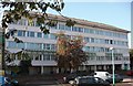
Image Map
Images are licensed for reuse under creativecommons.org/licenses/by-sa/2.0
Notes
- Clicking on the map will re-center to the selected point.
- The higher the marker number, the further away the image location is from the centre of the postcode.
Image Listing (176 Images Found)
Images are licensed for reuse under creativecommons.org/licenses/by-sa/2.0
Image
Details
Distance
1
Osprey Estate (part) Lower Road, Rotherhithe, London, SE16
The estate consists of seven buildings named :- Dunlin House (shown), Egret House, Fulmar House, Raven House, Sheldrake House, Siskin House and Tawney Way. The last is long and overlooks Lower Road. Built in the 1970's upon Maynard Road, Osprey Street, Trident Street and William Street. In 1868 Trident Street was named Wellington Street but changed before 1894.
Image: © Chris Lordan
Taken: 12 Oct 2009
0.02 miles
2
Dreadnought pub (site of). 251, Lower Road, Rotherhithe, London SE16
Just south of Plough Way, first recorded in 1849 and closed about 1993. Had three storeys with a mock Tudor frontage.
Image: © Chris Lordan
Taken: 19 Oct 2009
0.04 miles
3
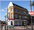
Merry Cricketers pub (site of). 276, Lower Road, Rotherhithe, London, SE16
At the junction with Bestwood Street (left) and first recorded in 1870. Believed that it ceased trading in the early 1990's. Externally unchanged from 1960.
Image: © Chris Lordan
Taken: 12 Oct 2009
0.05 miles
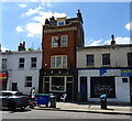
4
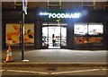
Foodmart on Lower Road, Bermondsey
It was Cost Less Express a year ago
Image: © David Howard
Taken: 12 Aug 2017
0.05 miles
5
The Farriers Arms
A traditional Irish pub on Lower Road.
Image: © JThomas
Taken: 20 Jun 2022
0.06 miles
6
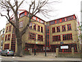
Marathon Science School, Deptford
A boys' secondary school on the corner of Evelyn Street and Croft Street.
Image: © Stephen Craven
Taken: 19 Apr 2014
0.07 miles
7
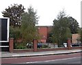
Sutton Dwellings (part), Plough Way, Rotherhithe, London, SE16
Paid for by the charitable trusts of the will of William Richard Sutton who died 20-05-1900. A total of eight blocks were built in 1915 and named "Block A" to "Block H". In the early 1970's a ninth was added and each block was renamed after villages/towns within the UK :- Ayston (pictured) : Biddenham : Codicote : Deanshanger : Emphingham : Freswick : Graveley : Husbourne : Jura
Image: © Chris Lordan
Taken: 23 Sep 2009
0.07 miles
8
Old Manor House (ex) 58, Bush Road, Rotherhithe, London, SE16
Stands opposite Bestwood Street and that's all I know about the building.
Image: © Chris Lordan
Taken: 30 Oct 2007
0.07 miles
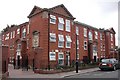
9
Houses on Croft Street, Deptford
The flat-topped entrance to the car park behind, with accommodation above, is an unusual detail in a modern building.
Image: © Stephen Craven
Taken: 19 Apr 2014
0.08 miles
10
Jura House, Plough Way, Rotherhithe, London SE16
Built about the early 1970s as the latest addition to the Sutton Estate. The site was previously that of St Barnabas Church which was consecrated 11-06-1872, five years after the death of the man who arranged its building - Rev. Edward Blick. It was from this church that the funeral procession of Field Marshal Sir William Maynard Gomm (died 15-03-1875) left for his interment at Christ Church, Jamaica Road, Rotherhithe. St Barnabas church was demolished in the late 1960s. In 1745 Plough Way was Little Rogue Lane.
Image: © Chris Lordan
Taken: 23 Sep 2009
0.08 miles