IMAGES TAKEN NEAR TO
Childers Street, LONDON, SE8 5BS
Introduction
This page details the photographs taken nearby to Childers Street, SE8 5BS by members of the Geograph project.
The Geograph project started in 2005 with the aim of publishing, organising and preserving representative images for every square kilometre of Great Britain, Ireland and the Isle of Man.

There are currently over 7.5m images from over14,400 individuals and you can help contribute to the project by visiting https://www.geograph.org.uk
Image Map
Images are licensed for reuse under creativecommons.org/licenses/by-sa/2.0
Notes
- Clicking on the map will re-center to the selected point.
- The higher the marker number, the further away the image location is from the centre of the postcode.
Image Listing (148 Images Found)
Images are licensed for reuse under creativecommons.org/licenses/by-sa/2.0
Image
Details
Distance
4
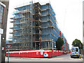
InSpace development under construction
A housing development on Childers Street, with the railway arches on the London to Greenwich line behind, under construction in summer 2009. See Image for the completed development.
Image: © Stephen Craven
Taken: 18 Jul 2009
0.05 miles
5
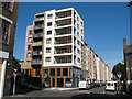
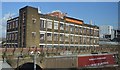
InSpace development, completed
A development of apartments on Childers Street, Deptford, built from 2009-11. See Image for the same block under construction.
Image: © Stephen Craven
Taken: 21 May 2011
0.05 miles
6

Childers Street: InSpace development
Since my previous view of this building in 2011 Image the ground floor has been occupied by PDERS Lifts.
Image: © Stephen Craven
Taken: 27 Oct 2014
0.06 miles
7
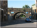
Rolt Street bridges
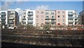
The two bridges shown here both carry railway lines from London Bridge: the nearer is the Greenwich/Dartford line, the further is to New Cross/Lewisham and beyond.
Image: © Stephen Craven
Taken: 21 May 2011
0.06 miles
8
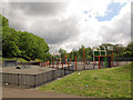
Skateboard park and basketball court
Part of the play area at the east end of the park.
Image: © Stephen Craven
Taken: 19 Apr 2014
0.06 miles

10
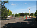
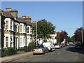
Playground in Folkestone Gardens
The playground at the east end of Folkestone Gardens, adjacent to Rolt Street.
Image: © Stephen Craven
Taken: 21 May 2011
0.07 miles