1
Housing on Trundleys Terrace (2)
A medium-rise housing block on the north side of Trundleys Terrace, seen from the ramp to the nearby railway footbridge. See also
Image
Image: © Stephen Craven
Taken: 27 Apr 2010
0.01 miles
2
Housing on Trundleys Terrace (1)
Trundleys Terrace is a short stub of a road off Trundleys Road. These few houses are on its south side. View from the railway footbridge.
Image: © Stephen Craven
Taken: 27 Apr 2010
0.02 miles
3
Old Manor House (ex) 58, Bush Road, Rotherhithe, London, SE16
Stands opposite Bestwood Street and that's all I know about the building.
Image: © Chris Lordan
Taken: 30 Oct 2007
0.03 miles
4
South of Surrey Quays
An Overground train soon after leaving Surrey Quays station is seen from a footbridge. The train is keeping to the eastern-most track so it's most likely heading for New Cross Gate and points south: West Croydon or Crystal Palace.
Photo number 7885441.
Image: © Robin Stott
Taken: 29 Aug 2024
0.04 miles
5
Footbridge at Deptford Road Junction
The footbridge over the former East London Line railway, linking Trundleys Road to Oldfield Grove, was rebuilt with access ramps each side as part of the redevelopment of the junction for the London Overground project.
Image: © Stephen Craven
Taken: 27 Apr 2010
0.04 miles
6
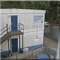
Network Rail establishment
Signed 'East London Line Infrastructure Maintenance Facility'. The view is from the ramp up to the footbridge that connects Oldfield Grove and Trundley's Terrace.
Image: © Robin Stott
Taken: 29 Aug 2024
0.06 miles
7
Southbound Overground train on the former East London Line
Image: © David Martin
Taken: 10 Apr 2022
0.06 miles
8
Beyond the Silwood Triangle, Deptford
What hits the eye are the towers of Canary Wharf. Between them and the camera, behind the fence, are a group of sidings for Overground trains. Just going out of view a train from New Cross or New Cross Gate heads for Surrey Quays.
Photo number 7881453.
Image: © Robin Stott
Taken: 29 Aug 2024
0.06 miles
9
Train by Somerfield Street, Deptford
An Overground train from the New Cross Gate direction and at a higher level than
Image, slows on the approach to Surrey Quays station. The building on the left turns out to be a Network Rail outpost, occupied by a contractor; it is an East London Line Infrastructure Maintenance Facility. This may be the site reached from Sainsbury's delivery compound at New Cross Gate
Image
Image: © Robin Stott
Taken: 29 Aug 2024
0.06 miles
10
Deptford Road Junction: first day of reopening
Unit 378152 on a journey from New Cross Gate to Shoreditch takes the new single track flyover crossing the route of the projected Peckham link line. The front of the train bears a poster with the London Overground logo and "first passenger train - April 2010". The lack of a precise date on the poster reflects the fact that the exact opening date was only known a few days in advance.
Image: © Stephen Craven
Taken: 27 Apr 2010
0.07 miles


